HNSKY version 4.2.10
     2023-01-23


Introduction
Getting started

Program operation
Searching for objects
Object menu
Go to menu
Mouse and keyboard control, Pop-up menu
Settings, tab settings
Settings, tab colours, font size
Sidereal or terrestrial view
Animation of planetary objects
Telescope control
Communication with remote host
Projection method
Saving and loading program status
Deep sky observations help file
Star databases and catalogues
Supplement edit menu with logbook capabilities
Some online demo videos

Additional information
Files required and optional
Non-English versions
Instruments and found markers
Printing
Angular measuring tools, mosaic design, found object markers.
Deep sky images from DSS and others
Eclipses of Sun and Moon
Moons of the outer planets
Comets and Asteroids orbital elements
Personal menu shortcuts
Supplement files
Units used in the program
Format of star, deep sky, comet, asteroid and supplement database files
Accuracy of the program
Server commands
Credits
History and future of this program

General astronomy information
Field of view and limiting magnitude of telescopes
Abbreviations used for visual description of deep sky objects.
Ephemeris or dynamical time
Constellations short names and positions
Planet and Moon data of our solar system
Bayer system for assigning Greek letters to stars
Glossary, technical terms and abbreviations

Download Links
Jet Propulsion Laboratory Development Ephemeris
Web pages of HNSKY and others


 If you're a native speaker, you're welcome to provide textual corrections. Translations or partial translations are also most welcome.
Introduction

"Hallo Northern Sky" or HNSKY is a full feature planetarium program for MS-Windows. Free with 30.000 deep sky objects and star databases up to magnitude 16. Online access to Gaia DR2 and UCAC4 star catalogs Access to local USNO UCAC4 catalogs. The Sun, Moon, the planets and their major moons are all displayed with surface features. It maps the position of comets and asteroids with online updating. It comes with hundreds of DSS deep sky images which will blend in at the correct size and orientation. It has a powerful animation menu. and an integrated deep sky observations help file and 21 non-English menus. It can control almost any telescope using the ASCOM interface program.

Downloading of additional DSS images via the internet is fully integrated. Just select an area and select download. After a few second the DSS image will blend in the HNSKY map at the correct size and orientation.

HNSKY showing M20

The comet or asteroid database can be updated online with just one click. You can also import orbital elements from JPL Horizons.
Online database search for objects in the selected area.

Numerical integration for asteroids to achieve highest accuracy positions years in the future or past. The error is less then 1" after 10 years !!! So a asteroid orbital elements from 10 years ago will after numerical integration allow position calculation within 1" accurate!! So also 10 years in the future.

The intention of the program is to familiarise you with the night sky and prepare yourself with a map for a night with your telescope. To help you with this, all deep sky objects are displayed in the correct size and orientation if available.

This program is free. Please distribute and enjoy it. Let me now if you liked it. Comments are always very welcome. This program stays Han Kleijn and you may not make money from it. Please distribute with original files only.

"Hallo" is the Dutch version of Hello.

Overview of the sky in "Azimuthal equidistant projection":


Under the main menu "HELP" the following quick overview is available:

Visibility of planets:

Yellow indicates if the planet is visible. The vertical axis are the next 31 days. The horizontal axis indicates the time from 17:45 hours up to the next morning 6:15 hours in steps of 15 minutes.

Dark night's (no Moon) are indicated as follows:

The vertical axis are the next 31 days. The horizontal axis indicates the time from 17:45 hours up to the next morning 6:15 hours in steps of 15 minutes.


Webpage: http://www.hnsky.org/software.htm

Other web pages

Back to the index
Getting started

Before the program show the sky correctly, you have first to set your location and time zone correctly


In menu SETTING (main menu FILE, sub menu SETTINGS or CTRL-E) tab Location you will see the following:


Location: You will notice a small red circle indicating the position on earth surface. The image on the left is showing the user location (7 degrees east, 50 degrees north in the Netherlands, Note the mouse geographical position will be shown the right bottom corner.

Time zone: The vertical yellow line is a help for checking if you have entered the time zone correctly. In the map it is indicating where the Sun is exactly at it's highest point at mid day and at the middle of the night is at 12 PM. So the red circle of your location and the yellow line zone should be close. In other words, the yellow line is indicating the middle of the time zone.

For USA en Europa the main time zones are available. If one of these is selected the daylight saving compensation will be automatic following the current definitions.

If your time zone is not available select the hourly difference with UTC time. See table below.

Daylight savings: In most countries during the summer the clock is set one hour forward. This is called daylight saving or summer time. To correct for this change, put check mark at "DAYLIGHT SAVING" if applicable. If daylight saving is active the map time hour/minutes separator is a dot as "23.00" else time is indicated as "23:00".

To save these location settings, select from the pull down menu "FILE" and then "SAVE STATUS". The location settings will be saved in the file DEFAULT.HNS. This settings file is automatically loaded after start-up

ΔT is hardly important. See subject 'ET and UT time' Normally you should keep this one selected.

Here is a list of some cities in each time zone:

Time
difference
with UTC
Cities in Zone
- 11 Midway
- 10 Honolulu
- 09 Anchorage
- 08 Los Angeles, San Francisco, Seattle, Las Vegas
- 07 Denver, El Paso
- 06 Chicago, Dallas, Mexico City, Houston
- 05 New York, Washington D.C., Boston, Montreal
- 04 Caracas, Santiago
- 03 Rio de Janeiro, Sao Paulo, Buenos Aires
- 01 Azores
+ 00 London, Greenwich Mean Time, Lisbon
+ 01 Paris, Rome, Madrid, Amsterdam, Berlin
+ 02 Cairo, Athens, Helsinki, Beirut, Jerusalem
+ 03 Moscow, Jeddah, Kuwait, Nairobi
+ 03:30 Tehran, Abadan, Shiraz
+ 04 Dubai, Abu Dhabi
+ 04:30 Kabul
+ 05 Karachi
+ 05:30 Delhi, Bombay, Calcutta, Colombo
+ 06 Dhaka
+ 06:30 Yangon
+ 07 Bangkok, Jakarta, Hanoi
+ 08 Hong Kong, Beijing, Taipei, Singapore, Manila
+ 09 Tokyo, Seoul, Pyongyang
+ 09:30 Adelaide, Darwin
+ 10 Sydney, Guam
+ 11 Noumea, Port vila
+ 12 Wellington, Auckland

Now you ready are with the setup. The only other thing to do is to set the time. You could set "follow the system time" and HNSKY will use the time of the computer for creating the sky map. However if you preparing for an observation night, maybe it is better to set it at midnight. The following options are available:


Main pull down menu "DATE" allows following time settings:


Follow computer clock. The map is updated regularly at an interval set in "SETTINGS" , TAB SETTINGS.

Tonight, the map is made for midnight 12 PM

Now, Map is made for current computer time but does not change

Enter date time, Enter any time in past or future.

Starting with version 3.0.2 the main menu is customizable. You can call up this pop-up menu with the right mouse button or by clicking on the triangle button on the right as shown below. Save the settings to make it permanent:


Back to the index
Searching for objects

With the SEARCH option, Alt-F, it is possible to search through the entire database. To find deep sky and solar object as NGC104, IC1396, M42 or the Moon, their full name should be entered. To find SAO, PPM and TYCHO stars enter their catalog number only. The text search of Tycho files and other .290 files goes from north to south and could be a bit slow. SAO and PPM and other DAT star files are organized from bright to faint and a text search for bright stars is faster. For each object only one name will be displayed on the map. Preference is given to the Messier name rather then NGC. So a search for object NGC1952 will display M1 on the map.

The search menu allows wildcards. If you type a search string such as PAN* and press the button COMETS, it will list all comets complying to this wildcard as 253P/PANSTARRS. Alternatively you could first press the button COMETS, then type the search string PAN* and finally hit Go To button. The combo box will list all comets complying to this wildcard.

See also subject 'Functional Keys'


To slew a telescope directly to object activate the option "slew to". To follow the telescope you could set the option "track telescope" in the telescope popup menu.

The local databases, including UCAC4 will allow a full database search. A search in the online UCAC4 and Gaia DR2 database will only inside look into the visible area.

Back to the index
Object menu


The top part "Stars" allows the selecting the star database and adjustment of star boldness and the number of stars displayed called density option. The primary star database is used for wide field displays. If selected, the secondary kicks in at high zoom factors.

The TYC as primary database is included. If you require more stars download the V16, V17 or G17 database.

Alternatively you could download and select (settings) the UCAC4 local for secondary. The  benefit of a local copy of the USCAC4 will only be some more star information, proper motion but limit field of view.

The reason for this dual setup is speed. For wide field it is convenient to sort the star database from bright to faint, so the few thousand brightest stars can be quickly accessed. All HNSKY native database are organized in this way. For large catalogues going very deep with many faint stars, the sorting is done on location to allowing quick access for a small area. The result is that it is a rather difficult the extract the few thousand brightest stars up to magnitude 5 from an original UCAC4 catalogue sorted on declination and 9 gigabytes large.

"Name all stars",  this option has three states. Off=bright database stars only, Grayed=supplement stars only. Checked=All star names.
"Asteroids" and "Comets" have three states. Off=display none, Grayed=display all,  Checked=auto, display depending on slider positions and zoom factor.

The bottom part"Deep sky + solar" allows selection of the deep sky database and two supplements in parallel. For most beginners the "Deep sky level 1" is sufficient. The database can be filtered on magnitude, size and type. At the bottom there are two sliders to adjust the background and brightness of the displayed deep sky images (FITS files) Normally you don't have to adjust them but some deep sky DSS pictures are under-overexposed and need some fine-tuning to get maximum detail.


The bottom part has a second TAB for three more supplements, the TOAST projection of the whole sky for displaying the Milky-Way (slow, use with care).

This TAB has one special option to filter out near-Earth object (NEO), both asteroids and comets closer then 0.05 a.u. to Earth. This is the only option which can not be saved by purpose.


Star colors. The V16, V17 based on Gaia and the Gaia online database allow coloring of the stars based on the difference in blue en red magnitude values. To activate this option selected G16 as primary database and check-mark the option "star colors". Stars which are brighter in blue are hot and coloured blue or cyan. Stars which emit equal amount are colored white and stars which emit more red/infrared light are colored yellow or red. See color table below. See also the general explanation of star spectral types


Star colors in HNSKY

Gaia Bp-Rp,
difference between blue and red magnitude:
Star color in HNSKY
<-0.25
Blue
-0.25 to -0.1
Cyan
-0.1 to 0.3
White
0.3 to 0.7
Yellow white
0.7 to 1.0
Yellow
1.0 to 1.5
Orange
>1.5
Red
No info
Green


Comparison PPM spectral class with Gaia for about 20 stars for each group
Spectral Type Surface Temperature Bp-Rp values Gaia Standard deviation
O > 25,000K    
B 10,000-25,000K 0.0 0.3
A 7,500-10,000K 0.3 0.2
F 6,000-7,500K 0.7 0.2
G 5,000-6,000K 0.9 0.3
K 3,500-5,000K 1.5 0.3
M0 < 3,500K 2.1  
C < 3,500K    


Back to the index
Go to menu


This menu allows to move directly to a position on the map. The North, South, East, West or Zenith buttons move straight to overall view in that direction. You can enter numbers with decimal fractions in all fields including the degrees and hours.

On the right bottom you can paste a position from Simbad or any other source. It will accept four or six string positions. All text will be removed. An "S" (=South) will introduce a minus sign. The following two examples will be interpreted correctly:

Simbad: Sirius 06 45 08.917 -16 42 58.02
Orion Nebula’s position is Right Ascension: 5h 35.4m; Declination: 5° 27′ south.

Back to the index
Mouse and keyboard control, Pop-up menu.

Mouse buttons:

Left mouse button:
1) Display data of the object near the cursor.
2) If cursor is close to the borders of the window, move left, right, up or down.

Right mouse button:
This will introduce a mouse pop-up menu with several options. While holding the right button you can also pull a rubber square which will be the area for the following:


Search for objects in the area selected in Simbad, Hyperleda or Ned or internal. If no area is selected search near mouse position. The Simbad, Hyperleda and Ned will create a search request in the default web browser. The internal search will produce a list in new window. Relevant data could be copied-pasted. If a planet is within the internal search area, the J2000, mean and apparent positions will be given.


Download from internet deep sky image defined by the square or near mouse position. HNSKY will store up to 9 images in the Documents directory as download1.fit, download2.fit.... After 9 files it overrides the first to prevent creating too many files. Normal DSSor DSS2 images are download as defined in the internet setting in menu SETTINGS tab 4.

For wide fields with a height above 3.5 degrees, Skyview provide the Axel Mellinger low resolution survey. The images are shown at any zoom and stored as downloadM1.fit, downloadM2.fit.... You can select in the internet setting in menu SETTINGS tab 4 an other survey like "HALPHA" or Mellinger colour green (MELL-G) or blue (MELL-B)

Furthermore the pop-up menu has the following menus:

Markers and lines
Telescope

To centre on an part of the display simply use "CENTRE ON":


To centre the map can be done in three other ways.

    1) Click the mouse wheel as a button,
    2) Pushing ALT KEY plus RIGHT or LEFT MOUSE button.
    ////3) Click twice with the LEFT mouse button.//// (remove 2018)

Mouse wheel:


Use the mouse wheel zoom in or out. To zoom in on a specific object, pull square box using the mouse while holding the left mouse button down. Use CTRL+Z to return to previous view. The distance and angle are give in the status bar. Clicking the mouse wheel as button will centre the map on that position

Keyboard:

Beside the ALT+key options for accessing the pull down menu items, the following hot keys are available in the pulldown menu:

General: Command: keys
General Move left,right, up, down: Arrow keys
Move slowly left,right...: CTRL+Arrow keys
Zoom in: CTRL+I or Alt-I or Page Down or Mouse scroll wheel.
Ctrl + Page Down  or Shift + Mouse scroll wheel for small steps.
Zoom out: CTRL+O or Alt-O or Page Up or Mouse scroll wheel.
Ctrl + Page Up  or Shift + Mouse scroll wheel for small steps.
Zoom in, small step: CTRL+Page Down
Zoom out, small step: CTRL+Page Up
Search: CTRL+F or Alt-S
Reset: Alt-R
Objects menu: CTRL+B or Alt-B
File Save Status: CTRL+W
Load CTRL+L
Load event CTRL+F
Settings: CTRL+E
Supplement 1: CTRL+1
Supplement 2: CTRL+2
Supplement 3: CTRL+3
Supplement 4: CTRL+4
Supplement 5: CTRL+5
Asteroid data editor: CTRL+8
Comet data editor: CTRL+9
Print white sky: CTRL+P
Copy the window: CTRL+C (as Windows copy)
Exit
CTRL+X
Screen Move To CTRL+M
North: shift+N shift !!!
South: shift+S
East: shift+E
West: shift+W
Zenith: shift+Z
Flip Horz: CTRL+H
Flip Vert: CTRL+V
Grid RA/DEC: CTRL+G
Grid Alt/Az: CTRL+A
Constellations: CTRL+K
Boundaries: CTRL+U
Animation CTRL+R
North always Up
CTRL+N
Cross hair: CTRL+Alt+H
Pointing circles
CTRL+Q
Draw solar object tracks: INS
Undo view: CTRL+Z
Redo view: SHIFT+CTRL+Z
Date System Time: CTRL+T
Now (time&date): F9
Enter Date Time: CTRL+D
Step one minute: F3, F4 ("ACTUAL TIME" should be off)
Step one hour: F5, F6 or +, - key
Step one day: F7, F8
Step 23:56: F11,F12 or CTRL and + ,CTRL and - key

Step 23:56 hours. This is very useful when monitoring a solar object over a long period while the star field reins stationary.


Some areas in the canvas can be clicked on. If a field is active, the mouse pointer will change to the standard arrow. There is an area at "date" to change the date, "position" to move to an other position.
/////If you want to know when an object is in the zenith, hold the mouse steady at the rise and set times. See below:////
remove 2018)

Copy object information in the clipboard.


After an object information is displayed, it can be copied to the clipboard by clicking on the status bar. Abbreviations are unconverted from the deep sky database.


Back to the index
SETTINGS, tab Settings


Location use: This one should be selected for accurate positions of planetary object.

Equinox: Select for the map equinox J2000. The telescope equinox will be set by ASCOM. The equinox 2000 is the common reference frame for maps and this one should normally be selected. An
astronomical reference system has conventionally been the extension of the Earth's equatorial plane, at some date, to infinity.  If you use HNSKY to control a telescope, you can either select for the map "mean equinox of date" or keep equinox J2000 selected but the communication for telescope should be in most cases "mean equinox of date". HNSKY will read and select automatically the correct setting from ASCOM communication if provided. Note that if a telescope is correctly polar aligned the mechanical drive will follow this "equinox of date" as the earth rotation does the same.  See topic equinox in glossary and telescope control.

Screen: If in main pull down menu DATE is set follow system time, the update interval is set in tab SETTINGS, tab Settings, part Screen. Typical you should set this at 5 minutes. If you select 0 minutes, the actual interval will be 1 second for animation. Planetary objects will now move in real-time with an update frequency of one second. This will create a high CPU load on your computer.

Screen mode:This should normally be selected. If selected the sky map is created in memory and displayed instantly.

USNO location:webpages. Note the UCAC4 can be used for small fields only. For background information see UCAC4

FITS image file settings This is the path to the FITS files of the deep sky and planetary images. The dot in the example represent the "Documents" folder.

Jet Propulsion Laboratory Development Ephemeris: For the highest planetary position accuracy download the DE430 or DE431 file from here. You could place the ephemeris file in the "Documents\hnsky" folder or program folder typically \Program files\hnsky . The small lnxp2000p2000p2050.430 file is covering the years 2000 to 2050. The huge lnxm13000p17000.431 (2.8gbyte) is covering the years -13000 to 16999.

If the JPL ephemeris is working correctly, you will see the letters DE in the blue title bar of HNSKY. If not the status bar will show a message "JPL... not found/invalid range". This message could be overwritten depending what you are doing. If the date is outside the valid range, the letters DE will disappear and the same status bar message "JPL... not found/invalid range" will be given.

There is a possibility to use two JPL ephemeris files. One small at position 1 with small date range and one with a large range at position 2. Even with the huge DE431 at position 1, the program is quick. The program will first try to use position 1, then position 2 and if no file is found or the date is outside the valid range it will fall back on the internal analytical solution. The internal analytical solution is only accurate between years 1750 and 2250. Only one JPL ephemeris file is sufficient.

Jupiter GRS offset, this setting allows to correct transit time of Jupiter's great red spot, the GRS. The GRS is a cloud feature, and like any other cloud feature, it moves slowly around the planet.  Jupiter doesn't rotate as a solid object; clouds near the equator rotate a little faster than those closer to the poles. HNSKY uses a estimate for calculating the transit times but slowly an offset will occur which could be compensated using this setting.  Up to date transit times based on resent observations can be obtained from the web. E.g. https://www.projectpluto.com/jeve_grs.htm

Documents path indicates where the FITS, supplements en cache files are stored. See requirements. This is normally the "hnsky" folder in the Documents folder. The installer will normally place user files in this folder. If this folder is not available, it will alternatively it will look for the files in the program folder. Note that under Win10 writing in the program folder is not possible and could block downloading DSS images and accessing online star databases unless the permissions of the HNSKY program folder are modified. So it is better to have the "hnsky" folder in the Documents folder.

Back to the index
SETTINGS, tab Colors

Colors: The grid, constellations, solar and deep sky colors and font size can be set in the menu "SETTINGS"(CTRL+E) of main menu "FILE".

Go to "PAGE" colors and just click with the mouse on the colors to change them.

The menu colors as any other window application are defined in your Windows set-up. To change these color settings, select "SCREEN" in your Windows set-up.

All these settings become permanent after selecting "SAVE STATUS" in menu "FILE".

Back to the index
SETTINGS, tab Internet access


These settings normally don't require any change.

The only thing you could change are parameters. You could change DDS2R (Second Deep Sky Survey red) to DSS2B (blue) or DSSR (First survey red). Each provider has a slightly different interface so changing the provider will not work.

Back to the index
SETTINGS, tab Update


From this tab the asteroid and comet database can be quickly updated. Same is possible within the editor.

The internet address for the asteroid ephemerides database (The SKY format) contains the current year. HNSKY will update the year in the path automatically based on the computer clock. In the first days of a new year it is possible that the update is not available yet from the minor planet center webpage. Is this the case, modify manually the year to the previous year. Note you can also the numerical integration option in the asteroid editor to update the ephemerides data.

Back to the index
SETTINGS, tab telescope

There a three interfaces to control a telescope:

ASCOM: For Windows users the easiest way is to select ASCOM and install ASCOM  and ASCOM mount driver for your telescope.

ALPACA: To control a telescope remotely through a netwerk you could select ALPACA. On the remote computer you have to install both 
ASCOM and ASCOM Remote (Alpaca)
HNSKY is the host which can connect to ASCOM Remote server running in a remote Windows computer. The local ASCOM remote server will communicate locally with the ASCOM mount driver. In the near future non-windows  Alpaca servers will be come available

INDI:  A third option is the INDI interface is available both for Linux and Windows versions. INDI is mainly used in Linux.


A local Linux server can be started with a telescope driver using  a command line or conveniently with the utility  INDI starter.  Two different setups could be used:

Server and HNSKY client in same computer:  Enter for the INDI server address "localhost" or 127.0.0.1. Port should be 7624.

Server and HNSKY client in different computers:  Enter the TCP/IP address of the server.  To find this address type in a  Linux  terminal the command IFCONFIG. Take the (IP4) inet addr. of eth0.  Port should be 7624.

The INDI client is used for settings of  the telescope mount driver. Most mount drivers have a simulation mode which can be set for testing. To use the simulation mode of the mount driver you have to set it "ON" in the INDI client before it is possible to connect the mount.  You could also use the generic telescope simulator for testing.


The Indi client.

Back to the index
Markers and lines


The "MARKERS AND LINES" allows you to draw deep sky outlines or your personal horizon and are stored in supplement 2.

Usage:

- Click on an existing object to use that name. (optional)
- Activate "DRAW LINES (Ra/DEC)"
- Click on the outlines of a deep sky object. Each time a line will be drawn.
- When finished deactivate "DRAW LINES (Ra/DEC)"
- Open supplement 2 and save outline as a .SUP file.
- When required last lines can be deleted with "DELETE LAST POINT".

Any change is not saved and requires a manual save of supplement 2 !!

Editing commands:

Line colour change mode: After activating this mode, hit the end point of a line and on every click the colour changes.

Insert line mode: After activating this mode, hit the end point of a line and on next click an extra line is inserted at that next point.

Remove line mode: After activating this mode, hit the end point of a line and the line is marked as comment with ;$$$ in front.

Hide line: After activating this mode, hit the end point of a line and the line command is changed from "line to =-1 to "move to"=-2 or the other way around. Works also for Az/Alt lines.

Be aware the the line commands are a series. For example these three commands will draw two lines:
1) "move to point A", 2) "line to point B", 3) "line to point C".

If you remove a start point of a constellation e.g. "move to point A", A new line from somewhere will pop-up to "point B". You have to apply the hide line on "point B" to make it a "move to point B" to remove this line.

Mosaic design
It is possible to draw and export rectangles to design a mosaic imaging session. See topic
angular measuring tools, mosaic, found object markers.


Back to the index
Sidereal or terrestrial view


1) Sidereal view off (=Terrestrial view:
- Stars rotate around celestial north (Polaris) as time goes by.
- Altitude and horizon grid are fixed as time goes by.
- RA/DEC grid follows stars and rotates around the celestial north as time goes by.
- In the short term solar objects are going around similar as stars.

Terrestrial view is what you see if you just look to the sky and is caused by the rotation of the earth.

2) Sidereal view on:
- Stars are fixed on the map as time goes by
- Altitude and horizon grid rotate as time goes by.
- RA/DEC grid is fixed.
- Solar objects are moving slowly on the fixed map.

Sidereal view is what you see through the telescope while having the sidereal drive on. The so called diurnal motion of stars is off.

3) In the third option is to follow planetary object in the Animation Menu.

Back to the index
Animation of planetary objects


To activate this menu, select via menu "SCREEN", "ANIMATION" (Ctrl+R). You could activate and use the animation button in the menu.

The animation menu handles three topics:

1) Object to follow: Follow a planetary object or the stars (sidereal) or nothing (terrestrial view) while time changes.

2) Time step: Change the time in a single or many steps. The many steps or animation are started with the "<<" or ">>" button. If tracks is activated the planets make a track for every step. The forward animation ">>" can be also started with key "INS" (or with menu "SCREEN", "INSTRUMENTS", "DRAW SOLAR OBJECTS")

3) Find an eclipse or occultation: This will show for your location the next or previous eclipses or occultation s. For the lunar option, all planets and the bright star Aldebaran are checked against the Moon position. For the solar option, the position if the Moon, Mercury and Venus are checked against the Sun position. The date and time show are just for the start of the phenomena.

The solar combo box list list will be filled with up to 10 object names where you click on.

To make animated movies, you should use an additional screen recorder program.
if you want to make a movie of Jupiter and its moons do the following:

    1) Lock on Jupiter by typing or clicking on Jupiter and activated option "Solar".
    2) Set the date to the beginning of the event.
    3) Select a small step size e.g. 1 minute and duration of 500 steps.
    4) Hit the ">>" or key "INS" to animate.

It could be beneficial the orientate the top of the MAP to the North by menu "SCREEN", "NORTH ALWAYS UP" (Ctrl+Alt+N)

Back to the index
Telescope control


HNSKY can work together with ASCOM, a free third party telescope interface. ASCOM has drivers for almost any telescope. First you have to download and install the ASCOM program from http://ascom-standards.org

As soon you activate the ASCOM interface by the right mouse button pop-up menu or CTRL+7, the ASCOM window will pop-up. This window will allow telescope selection. For testing purposes you could select the ASCOM telescope simulator. Please select "Telescope simulator for .NET" rather then the older "Simulator".

Equinox: The telescope position will become visible as a cross. For maximum accuracy, the telescope and HNSKY should communicate in the same coordinate system. See menu SETTINGS (CTRL+E), setting EQUINOX, TELESCOPE. Most controlled telescopes communicate in "mean equinox of date" coordinates. HNSKY normally sets this automatically by reading from the telescope the equinox used using the ASCOM protocol. In this case you will not be able to change the telescope equinox and the correct equinox for communication will be used. Depending on the indication in your telescope you could select for the map either "mean equinox of date" or J2000 till they indicate the same. See menu SETTINGS (CTRL+E).

Note that if a telescope is correctly polar aligned, the mechanical drive will follow this "equinox of date" as the earth rotation does the same. For this reason it is convenient to communicate in "mean equinox of date" coordinates rather then do a conversion in the telescope to a different epoch.

The telescope position is indicated in the top caption of the HNSKY window.

Note: The ASCOM simulator allows setting equatorial system communicated for testing purposes. HNSKY will follow.

The telescope pop-up menu has the following commands:

Telescope to here, slew the  telescope to mouse position.  Note that slew to an object can be done from the
search window by activating the option "slew to" and then search for an object.

Sync to mouse position, matches the telescope's coordinates to the mouse position.

Abort slew, Stops a slew in progress.

Follow solar object. The telescope and map will  follow the object on refresh. First select the object by clicking on the object with a left mouse mouse button. Then click on the right mouse button and select TELESCOPE, FOLLOW OBJECT (selected).  The "follow system time" in the pull down menu DATE should have been activated. In
menu  SETTINGS, tab SETTINGS" you can set the "frequency of the screen update. (rev 2019-10)

If the "frequency of screen update" is set to zero the interval will be not zero minutes but one second. This could be used to track a comet, Moon or any other solar object on it's calculated track!!. HNSKY will send every second and new calculated position to the telescope. If the telescope mount has an accurate polar alignment, this could be used for a long time exposure of a comet without the need for stacking. This could be called MATH GUIDING. To reduce the computer load it could be beneficial to switch of star and deep sky database.

A better solution is to guide on a nearby star with a program like PHD2 and set the comet diurnal motion offset in PHD2. HNSKY will give the velocities of comets and asteroids in arc sec/hour in the status bar which could be entered directly in PHD2 for that purpose.

Track telescope, Map will follow telescope.

Connect to telescope, connect via ASCOM driver to the telescope.

If you double press the left mouse button while holding the  CTRL key down the telescope with go to the mouse position. (2018)

Back to the index


Communication with remote host
 
HNSKY FPC version has a TCP/IP server which can communicate with
astro photography tools as  APT & CCDciel .  To activate put a check mark in front of "use TCP/IP server" in the menu SETTNGS (CTRL-E).


Depending on the integration the remote host can:


HNSKY provides to the remote host:


The used server commands are described in section server

 
Back to the index


Projection methods.

Azimuthal equidistant projection. For a better over all view of the sky, the "azimuthal equidistant projection" is available. This projection method allows very wide views up to almost to 360 degrees. The radial distances and direction measured from the centre of the map are correct but the disadvantage is a distortion for large fields of view.

You could select a RA/DEC or Alt/Az grid for orientation. The horizon is shown as a double thick line. The horizon line will disappear if the same colour is selected as the RA/DEC grid.


Orthographic or spherical projection method. The sky is projected on a sphere and in the middle of this sphere lies the Earth. You are observing from outside this sphere with the corrected left and right orientation. This projection method allows wide views almost to 180 degrees. Disadvantage near the edge there is a distortion.


At high zoom factors, both projections produce identical maps.

See also subject 'Saving and loading program status'

Back to the index
Print screen.

Printing. The printing routine will rebuild and adapt the screen view to the printer resolution. Laser printers will produce sharp and good quality prints. The size of the window and monitor resolution are irrelevant.

From version 3.2.2b the size of the printed stars is no longer adapted to the DPI resolution of the printer. A low resolution of of 72 or 144 DPI will give the correct star size (a few pixels) for printing on paper. If you select 1200 DPI you will get much smaller stars (still a few pixels), more intended for zoom-able digital maps. You could use this for printing to PDF

The are two print options: Black stars on a white background or inverse white stars on a black background. If the print option "white background" is selected, the intensity of colors will be adopted accordingly. For example, a very bright yellow Moon in a black sky will be adapted to a white sky as very dark yellow Moon. Identical as white stars become black on a white background.

Another option is to copy the screen contains to the windows clipboard using CTRL+C or the menu option "COPY WINDOW TO CLIPBOARD" in the main menu "SCREEN". Then paste it (CTRL V) in your favourite graphic program for further processing as saving or printing. With this option the resolution is depending on the original HNSKY window size.

A third option is to use the standard Window feature to copy the complete window in the windows clipboard by using the ALT-PRINT SCREEN keys. This will capture the complete window including menu bar. Then paste it (CTRL+V) in your favourite drawing program.

Back to the index
Deep sky observations help file.


Deep sky observations help file for use with the HNSKY planetarium program. It is a compilation of more then 10.000 visual observations by Steve Gottlieb, Steve Coe and Tom Lorenzin. In HNSKY after you found an object or clicked on it, just hit the F2 button and the CHM file will display the available observations of that object. Rather then F2, you can go the main menu HELP and select the second menu indicating the last object found. Or just look around in the index of the deepsky.chm file.

Back to the index
Star databases and catalogues.

Here an overview of the available star database and accessible catalogues:

Star databases:

Local star
databases
Name Abbreviation Magnitude limit Colour / Mono Type Size Maximum
field
in HNSKY
Proper motion Description and download link
TYC++
TYC
12.5
Mono
Local files, native 290-10 format
45 MB
360° No, epoch
2017
Native HNSKY star database up to magnitude 12.5 containing 4.7 million stars. compilation from TYCHO-2 UCAC4. Included with the program and installed.
TUC
TUC
15
Mono
Local files, native 290-9 format 341 MB
360° No, epoch
2017
Native HNSKY database up to magnitude 15 containing 39 million stars. Compilation from TYCHO-2 and UCAC4. Contains the Tycho and UCAC star labels/designation. Unpack in the program directory, typically c:\program files\hnsky.
Gaia
V16
16 V-magnitude Colour
Local files, native 290-6 format 346 MB 360° No, epoch
2022
Native HNSKY database up to Johnson V magnitude 16 containing 60 million stars. Magnitude is the calculated Johnson-V magnitude. This V magnitude is close to the visual magnitude but not the same. 455 bright Tycho2 stars are added for completeness. Unpack in the program directory, typically c:\program files\hnsky or for Linux /opt/hnsky.

Recommended for visual observers.
Gaia
G17
17 BP-magnitude
Mono
Local files, native 290-5 format 503 MB 360° No, epoch
2022
Native HNSKY database up to photographic magnitude 17 containing 105 million stars. Magnitude is the unmodified Gaia BP. 455 bright Tycho2 stars are added for completeness. Unpack in the program directory, typically c:\program files\hnsky or for Linux /opt/hnsky.


Recommended for  astrophotographers.
Gaia
V17
17 V-magnitude
Colour
Local files, native 290-6 format 695 MB
360° No, epoch
2022
Native HNSKY database up to Johnson V magnitude 17 containing 121 million stars. Magnitude is the calculated Johnson-V magnitude. This V magnitude is close to the visual magnitude but not the same. 455 bright Tycho2 stars are added for completeness. Unpack in the program directory, typically c:\program files\hnsky or for Linux /opt/hnsky.

Recommended for visual observers.
Gaia
G18
18 BP-magnitude Mono
Local files, native 290-5 format 996 MB 360° No, epoch
2022
Native HNSKY database up to photographic magnitude 18 containing 208 million stars. Magnitude is the unmodified Gaia BP. 455 bright Tycho2 stars are added for completeness. Unpack in the program directory, typically c:\program files\hnsky or for Linux /opt/hnsky.

Download HNSKY 4.0.0g  to see the faint stars in this database.!
UCAC4
UC4
16
Mono
Local files, external USNO
format
8.4 GB
2.6x1.3° Yes
UCAC4: You can download the 113 million stars, 8.5 Gbytes large USNO UCAC4 from ftp://cdsarc.u-strasbg.fr/cats/I/322A/UCAC4/ HNSKY can access this catalog directly. Download Z001 to Z900 from the U4b directory and add to the same directory file u4index.unf from U4i. This UCAC4 and Gaia DR2 online are the catalogues where HNSKY will use proper motion for maximum accuracy. See
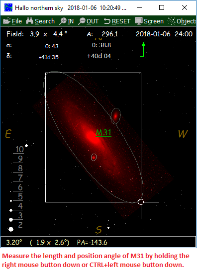
 HNSKY UCAC screenshots.
Online catalogues Name
Abbreviation Magnitude limit Colour / Mono Type
Size Maximum
field
in HNSKY
Proper motion Description
Gaia G
21
Colour
online
-
1.4x0.8° Yes
Gaia DR2
UCAC4 UC4 16 Mono
online - 2.6x1.3° Yes The USNO UCAC4 includes positions, proper motions and magnitudes for 113 million objects
Nomad
N
21
Mono
online
-
1.4x0.8° Yes
Obsolete: NOMAD is merged catalog compiled by the USNO, with positions and magnitudes for 1.1 billion stars from several source catalogs, including Hipparcos, Tycho-2, UCAC 2, and USNO-B 1.0
PPMXL
P
20
Mono
online
-
1.4x0.8° Yes
Obsolete: PPMXL is a catalog of positions, proper motions, 2MASS- and optical photometry of 900 million stars and galaxies, aiming to be complete down to about V=20 full-sky. It is the result of a re-reduction of USNO-B1 together with 2MASS.
URAT U
18.5
Mono
online
-
1.4x0.8° Yes
Obsolete: By USNO, northern sky only, extends down to Declination -15°.228 million objects


Back to the index


Supplement edit menu with logbook capabilities.

The
supplements can be freely modified in the main editor.  For convenience HNSKY provides and additional edit menu to access a single entry:


After an object/entry of a supplement is found, it is possible to edit the entry by moving&click the mouse in the info area at the left top of the screen. In the field "type" additional info as a log could be entered. Select "Save suppl" to make the change permanent. This works only for supplements not for the database(s).


New entry:


The menu-shortcut "HOME" key or via popup menu "Markers and lines, "Add object", will add a marker to the second supplement. In the supplement a line will be added with the mouse position, supplement line number and date.  You could use the above menu to add an observation in the field "type".  This marker & observations are only permanent after saving the supplement.   

In the supplement the entry "_56" with the observation could look as follows:
	1.559949,,, 30.381647,,,,_56/2017-08-06    ,Log/Seen with 8 inch telescope. Bright star or blob ?,-99

Back to the index


Spectral types of stars.

The spectral types of stars are defined with two characters. The first defines the main spectral type as follows:

Class letter
Temperature Conventional color description Actual apparent color
O
≥ 30,000 K blue blue
B
10,000–30,000 K blue white deep blue white
A
7,500–10,000 K white blue white
F
6,000–7,500 K yellow white white
G
5,200–6,000 K yellow yellowish white
K
3,700–5,200 K orange pale yellow orange
M
2,400–3,700 K red light orange red

The main types grade are subdivided decimally as: A0, A1, A2, A3, A4, A5, A6, A7, A8, A9, F0, ....
There are also some special spectral types as R, N, S, C for the carbon stars, W for the Wolf-Rayet stars and Q for novae

For more information, https://en.wikipedia.org/?title=Stellar_classification

Back to the index
The Saguaro Astronomy Club or SAC deep sky database.

The Saguaro Astronomy Club or SAC deep sky database contains as good as all deep sky objects visible in amateur telescopes.
The SAC compilation of data was begun in an effort to provide a comprehensive observing list for use at the telescope. Their data is released for private use by anyone who wishes to use this database.
Please do not sell this database in any form. The database in ASCII format can be download from their web pages.
The HNSKY database is a compilation of the SAC DEEP SKY DATABASE VERSION 8.1 and Wolfgang Steinicke NGC/IC database.

Back to the index
The "Smithsonian Astrophysical Observatory Star Catalog" (SAO, SAO Staff 1966).

HNSKY is using the updated and corrected version from May 1991, available from the CDS. This star catalog is complete to magnitude 9.0 but in some areas the limiting magnitude was raised to magnitude 10. The original ASCII format is converted to the HNSKY format

Back to the index
Catalogue of Positions and Proper Motions (PPM) north, south.

A convenient, dense, and accurate net of astrometric reference stars that represents the new IAU (1976) co-ordinate system on the sky.

Compiled by Roeser S., Bastian U.

    - PPM North Star Catalogue (181731 stars, 1988)
    - PPM South Star Catalogue (197179 stars, 1992)

Since its appearance in 1966, the SAO Catalogue (SAO, 1966) has been the primary source for stellar positions and proper motions. Typical values for the rms errors are 1 arc sec in the positions at epoch 1990, and 1.5 arc sec/century in the proper motions. The corresponding figures for the AGK3 (Heckmann et al., 1975) on the northern hemisphere are 0.45 arc sec and 0.9 arc sec/century. Common to both catalogues is the fact that proper motions area derived from two observational epochs only. Both catalogues are nominally on the B1950/FK4 co-ordinate system.

The PPM Star Catalogue (Roeser and Bastian, 1991, Bastian et al., 1993; for a short description see Roeser and Bastian, 1993) effectively replaced these catalogues by providing more precise astrometric data for more stars on the J2000/FK5 co-ordinate system. Compared to the SAO Catalogue the improvement in precision is about a factor of 3 on the northern and a factor of 6 to 10 on the southern hemisphere. In addition, the number of stars is increased by about 50 percent. Typical values for the rms errors on the northern hemisphere are 0.27 arc sec in the positions at epoch 1990, and 0.42 arc sec/century in the proper motions. On the southern hemisphere PPM is much better, the corresponding figures being 0.11 arc sec and 0.30 arc sec/century. The PPM catalogues (ftp://cdsarc.u-strasbg.fr/cats/I/146, ftp://cdsarc.u-strasbg.fr/cats/I/193) are available in ASCII format from the Centre de Données astronomiques de Strasbourg

Note: These ASCII catalogues can't be accessed by HNSKY directly conversion. Converted version is already available!

Back to the index
Catalogue of Positions and Proper Motions (PPM) supplements.

==The 90000 Stars supplement to the PPM Star Catalogue (89676 stars,1994)==

The improvement over the SAO Catalogue was made possible by the advent of new big catalogues of position measurements and by the inclusion of the century-old Astrographic Catalogue (AC) into the derivation of proper motions (for a description of AC see Eichhorn, 1974). But even PPM does not fully exploit the treasure of photographic position measurements available in the astronomical literature of the last 100 years. The Astrographic Catalogue contains roughly four million stars that are not included in PPM. For most of them no precise modern-epoch position measurements exist. Thus it is not yet possible to derive proper motions with PPM quality for all AC stars. But among the 4 million there is a subset of some 100,000 CPC-2 stars that are not included in PPM. These stars constitute the 90,000 Stars supplement to PPM.

==The Bright Stars Supplement (275 stars, 1993)==

A number of bright stars is missing from the PPM Star Catalogue, both on the northern and on the southern hemisphere. The Bright Stars Supplement described here makes PPM complete down to V=7.5 mag. For this purpose it lists all missing stars brighter then V=7.6 mag that we could find in published star lists. Their total number is 275. Only 2 of them are brighter then V=3.5 This replaces the December 1992 edition of the Bright Stars Supplement which inadvertently contained 46 duplicates of stars already contained in the main parts of PPM.

The PPM supplement catalogues ftp://cdsarc.u-strasbg.fr/cats/I/208/ are available in ASCII format from Centre de Données astronomiques de Strasbourg

Note: These ASCII catalogs can't be accessed by HNSKY without conversion. Converted version is already available!

Back to the index
New General Catalog (NGC).

Included in the main deep sky database.

The popular New General Catalog was compiled by the astronomer J.L.E. Dreyer (1852 - 1926) and contains information on 7,840 objects. Object types include galaxies, nebulae and clusters.

Index Catalog (IC)

The Index Catalog. By 1908 J.L.E. Dreyer compiled an additional list of 5,386 objects to his NGC catalog.

Back to the index


Back to the index
Tycho-2 information.

The Tycho2++ is the standard star database used in the HNSKY program. Format is in the 290 format. It is made from the combined Tycho-2 and UCAC4 star catalogues free available from the CDS(Centre de Données astronomiques de Strasbourg) webpage. The Tycho-2++ contains 4,7 million stars if which 2.5 million Tycho stars and additional about 2.2 million UCAC4 stars to make it complete up to magnitude 12.5.

The reason the UCAC4 was not used completely is the poor magnitude value for some bright stars. This compilation was created by adding all UCAC4 star without an HIP, FK6 or Tycho label to Tycho-2. The only exception is the Polar star. This star was due to it's importance added manually. It is include in original Tycho-2 but without position and labelled with flag HIP source in UCAC4 so omitted in the automatic merge.

The star proper motion is not included, but an update with the correct epoch (currently 2017) will released.

The star labels of both the Tycho-2 and UCAC4 stars, magnitude and accurate position are preserved in the very compact HNSKY format of 11 bytes only. See .290 format description.

Total size of Tycho-2++ is about 46 Mbyte. Up to magnitude 7 it contains 147 UCAC4 stars and up to magnitude 10 it contains only 336 UCAC4 stars.

Abstract:

The Tycho-2 Catalogue is an astrometric reference catalogue containing positions and proper motions as well as two-colour photometric data for the 2.5 million brightest stars in the sky. The Tycho-2 positions and magnitudes are based on precisely the same observations as the original Tycho Catalogue (hereafter Tycho-1; see Cat. <I/239>)) collected by the star mapper of the ESA Hipparcos satellite, but Tycho-2 is much bigger and slightly more precise, owing to a more advanced reduction technique.

Components of double stars with separations down to 0.8 arc sec are included. Proper motions precise to about 2.5 mas/yr are given as derived from a comparison with the Astrographic Catalogue and 143 other ground-based astrometric catalogues, all reduced to the Hipparcos celestial coordinate system. Tycho-2 supersedes in most applications Tycho-1, as well as the ACT (Cat. <I/246>) and TRC (Cat. <I/250>) catalogues based on Tycho-1. Supplement-1 lists stars from the Hipparcos and Tycho-1 Catalogues which are not in Tycho-2. Supplement-2 lists 1146 Tycho-1 stars which are probably either false or heavily disturbed.

For more information, please consult the Tycho-2 home page: webpages


Back to the index
The UCAC4 star catalog.

If you want star proper motion implemented or the original designation you could download the 113 million stars, 8.5 Gbytes large USNO UCAC4 from ftp://cdsarc.u-strasbg.fr/cats/I/322A/UCAC4/ HNSKY can access this catalog directly. Download Z001 to Z900 from the U4b directory and add to the same directory file u4index.unf from U4i. This is a catalog where HNSKY will use proper motion for maximum accuracy.

Link in menu SETTINGS to this U4b directory.

For more information download the readme files from the web Page mentioned above.

The magnitude error is larger then for the Tycho catalog. HNSKY will select the brightest value from "UCAC fit model magnitude", "UCAC aperture magnitude" and "B magnitude from APASS". The 2MASS unique star identifier is displayed in the status bar of HNSKY.

Here an example of NGC884 & NGC869 using the UCAC4:

Abstract:

UCAC4 is a compiled, all-sky star catalog covering mainly the 8 to 16 magnitude range in a single bandpass between V and R. Positional errors are about 15 to 20 mas for stars in the 10 to 14 mag range. Proper motions have been derived for most of the about 113 million stars utilizing about 140 other star catalogs with significant epoch difference to the UCAC CCD observations. These data are supplemented by 2MASS photometric data for about 110 million stars and 5-band (B,V,g,r,i) photometry from the APASS (AAVSO Photometric All-Sky Survey) for over 50 million stars. UCAC4 also contains error estimates and various flags. All bright stars not observed with the astrograph have been added to UCAC4 from a set of Hipparcos and Tycho-2 stars. Thus UCAC4 should be complete from the brightest stars to about R=16, with the source of data indicated in flags. UCAC4 also provides a link to the original Hipparcos star number with additional data such as parallax found on a separate data file included in this release.

The proper motions of bright stars are based on about 140 catalogs, including Hipparcos and Tycho, as well as all catalogs used for the Tycho-2 proper motion construction. Proper motions of faint stars are based on re-reductions of early epoch SPM data (-90 to about -20 deg Dec) and NPM (PMM scans of early epoch blue plates) for the remainder of the sky. These early epoch SPM data have also been combined with late epoch SPM data to arrive at proper motions partly independent from UCAC4 (Girard et al. 2011). The NPM data used in UCAC4 are not published. No Schmidt plate data is used in UCAC4.


Back to the index


Example load event.

You have just have just adjusted the date at 2002-7-25, 3:30 UT and zoomed in to M1. Saturn is eclipsing M1. This event can be saved as"Eclipse of the Crab nebula by Saturn". To recall this event, justload this file as an event. The time of the event, position and zoom factor will be returned.

Back to the index
Saving and loading program status.


Save status in the pull down menu "File" will save all your settings including your position on Earth, equinox, parallax, time zone, window size. These settings are stored in the file DEFAULT.HNS. After start-up these settings are loaded again automatically. Depending on your setting in main menu "SETTINGS", the program will start with the view at midnight or actual. The save/load option behaviour is different for high and low magnifications or zoom factors. For high zoom factors, the program will return the same RA/DEC as saved. Due to time differences, the view will be slightly rotated, unless load event to restore original time and date is used. For low zoom factors, the program will always return the same Azimuth/Altitude as saved. This is good for start-up overviews such as a wide view to the south.

Save as The program settings are saved in a different file then DEFAULT.HNS. "Save as" is a helpful tool to find and restore your favourite object.

Load status The saved status is restored. This will not (unless your load DEFAULT.HNS) effect your settings for position on Earth, equinox, parallax, time zone, window size and time settings)

Load event As load status but also the original time and date are restored.

Example load event

See also subject 'Projection method'

Back to the index
Instruments and found markers.

Several instruments are available:


Several found markers are available:


Back to the index
Program files.

The following files are part of the program:

Located in: C:\Program Files\hnsky:

hnsky.exe Main program
sao_hsky.dat Star database,SAO stars to magnitude 9.5
ppm_hsky.dat The PPM star database and supplements to magnitude 10.0 (468861 stars)
tyc_*.290 Tycho-2 star database containing 2.5 million stars. .290 file format. (32 files).
Deep sky level 1.hnd
Deep sky level 2.hnd
Deep sky level 3.hnd
- Small deep sky databases with 267 selected objects. Good start for beginners.
- Large deep sky database with 2600 objects. Up to magnitude 12. GX>=1 arc min.
- Very large deep sky database with 26000 objects. Up to magnitude 15.5. GX>=1 arcsin.
deepsky.chm Deep sky help file containing more then 10.000 deep sky observations by Steve Gottlieb, Steve Coe and Tom Lorenzin.
*.ini
Non English menu translation files

Located in: Documents\hnsky

hns_com1.cmt
The comet database.
hns_ast1.ast The asteroid database.
hns_****.sup Several deep sky and star supplements files, in ASCII format. (Milky Way, Yale catalog, binary and variable
stars, messier objects, world map.
*.hns
Setting and event files in ASCII format.you can load/save. During start-up 'default.hns is loaded'

Located in: Documents\hnsky\fits

*.fit 
Several deep sky and planetary images in FITS format.

Located in: Documents\hnsky\cache

*.txt Cache of online downloaded star catalogues UCAC4, Gaia DR2.

The above files locations are for v3.0.1 and higher
The Windows hidden "Application Data" directory is not used by purpose.

New fresh installations of the program will by default be placed in the "c:\Program Files\hnsky" directory. Existing installations will stay in the previous selected directory such as "c:\hnsky". If you want to move the new location, then save your default.hns settings file somewhere else, uninstall the old version, install the new version and copy & overwrite the default.hns file.

The following databases can be accessed directly if downloaded:

UCAC4 113 million stars, dated 2014

Instead of the above mentioned local UCAC4 you could access online:

UCAC4 (obsolete)
Gaia DR2

UCAC4 (local & online) and Gaia DR2 are the only databases which will provide star proper motion.

The online FITS files and UCAC4, Gaia DR2r cache files are placed in the FITS directory. The star cache files can be cleared form the FILE menu, "Delete online cache", however the will not slow down the program in any way. The online downloaded FITS files can be deleted from the pop-up menu.

Selection of deep sky databases: The different databases can be selected in the "OBJECT menu". For beginners it is advisable to select the small deep sky database HNS_SAC1.DAT which contains 265 easy and/or interesting objects including all Messier deep sky objects. For all these object, there are FITS images available which will blend automatically in the map if required.

Back to the index
Non-English versions.

Menus:

HNSKY is available in several languages. The translated text is stored in one INI file. To select an other language INI file go to FILE menu, sub menu SETTINGS (CTRL+E) and select the desired language file.

With any text editor, you could create a new language module for HNSKY. If your native language is missing, your are invited to create a new language module. Download the English module from The HNSKY web page, translate it and send it back to me.

Help file:

Available in English, Spanish and
Catalan. Some obsolete translations are still available:  Italian, Romanian, Korean, Volunteers to update or create new translations are welcome.

Back to the index
Personal menu shortcuts.

All non English versions including the English module have the possibility to add your personal menu shortcuts.

For example if you look inside the file ENGLISH.INI in HNSKY directory, you can modify the menu shortcuts. This looks like:

    savesettingsS   = CTRL+W
    loadS           = CTRL+L
    loadeventS      = CTRL+J
    locationS       = CTRL+E
    asteroideditorS = CTRL+1
    cometeditorS    = CTRL+2
   
All labels should be there. Removing them will result in blank menu items.

You could enter keys such as W or CTRL+W or Alt+W or CTRL+Alt+W. Single letters such a W (except F1, F2 ...) are not recommended, since they will block typing in the SEARCH menu.

To disable these files, delete or remove the *.ini file(s). The original English text and menu short cuts will return. You could also delete the settings file "default.hns" but you will loose all you settings including you position.

Back to the index
Units and spectral types:

Brightness: Magnitude pro square arc minute.

Size: Size or diameter in arc minutes. In case an " is displayed, the diameter is in arc seconds (typical for planets)

Spectral types of stars:

The spectral types of stars are defined with two characters.

See also subject 'Database files of stars and deep sky objects'

Back to the index
Accuracy of the program:

General remark: HNSKY has a high accuracy. To get comparable and correct ephemerides it is important to set:

    1) Geographical position on Earth correct.
    2) Time zone and day light savings. When necessary check the UTC time in the pull down menu "ABOUT". To get maximum moon and Sun accuracy, select ΔT correction on.
    3) Desired equinox. Normally J2000.
    4) Correction for parallax error on for topocentric values and off for geocentric values.

For 2) See subject 'ET and UT time'
For 2) For time zone of major cities see subject 'System time, time zone and location on Earth'

All positions of the Deep sky and planetary objects are astrometric referred to equinox J2000 (2000, January 1.5), equinox B1950, the mean equinox of the current date or apparent. These are the co-ordinates as they would appear to a stationary observer at the year 2000, 1950 or current date. Star positions in J2000 or B1950 may be compared directly with planet positions. The mean position is depending on the orientation of the earth of that epoch. The apparent position are the mean positions corrected for the velocity of the moving Earth aberration and wobble of the earth axis nutation. These aberration and nutations are effecting both stellar and planet positions equally (max. 30 arc seconds) and does no effect the displayed map.

The desired equinox can be selected via main menu "FILE" and then menu option "SETTINGS".

Date and time setting:


Enter the required date and time in the "set time" menu. The day of the month can be entered with fraction. So entering 30.5 will give day 30 at 12 noon.
It follows the astronomical year numbering including year 0. Historians did not use the Latin zero, nulla, as a year, so the year preceding AD 1 is 1 BC. So year -44 is "45 BC"

The build in monthly calendar doesn't allow a date beyond 1752 and 9999 so a parallel input is created.


Alternatively you could enter the date as Julian day in the JD tab.

Valid dates of the program :

The program has an internal analytical planetary solution which is accurate for dates between the year 1750 and 2250, except for Pluto, which is only accurate between 1890 and 2100. For a longer period or higher accuracy download the JPL Propulsion Laboratory Development Ephemeris DE430 or DE431. The DE431 covers the years -13000 up to 16999.

The internal analytical planetary solution is based on "Astronomy on the Personal Computer" by O. Montenbruck and T. Pfleger, 1998, English edition (Almost equal to 1993 edition). This is a very detailed book for Pascal programmers and contains several professionally written routines. The source code is on an attached disk. This book is not intended to be a teaching guide.

Ephemerides calculations for the moons of Mars, Jupiter, Saturn Uranus, and Neptune are based on their rotation period and their correct axis orientation (Theta) in space. Their rotation center position equals the planet position is known from the planet ephemerides. A basic X,Y,Z calculation is required to determine their final position in space. Their orbit is calculated as perfect circular, which is for the major moons more or less correct. Only for the Moons of Jupiter a correction for their gravitational interactions factors is made based on some factors found in the book of Meeus, Astronomical Algorithms edition 1991.

Accuracy of Planet and Moon ephemerides:

The internal ephemerides of the planets have a typical error of a few arc seconds with a maximum of about ten arc seconds. Only Neptune has a maximum error of about 40 arc seconds.

The internal ephemerides of the Moon are correct within about one arc second. It is important to select "ΔT correction" on to get accurate Moon eclipses. The resulting eclipse is correct within one maybe two minutes. The JPL Propulsion Laboratory Development Ephemeris should be spot on.

Rise and set time should be correct within, perhaps, two minutes. To get accurate rise and set times, the atmospheric refraction correction should be set "ON" (menu "SET EQUINOX AND LOCATION"). Light from objects close to the horizon is bent while passing through the atmosphere. Objects close to the horizon will appear to be higher then their actual position. At zenith, this effect is zero and increases towards the horizon. At an altitude of 45 degrees it is only 1 arc-minute. At an altitude of 10 degrees it is 5 arc-minutes and at the horizon it increases rapidly to about 35 arc-minutes.

See explanation of atmospheric refraction in the glossary

Note that the rise and set time are given for a date. So if the HNSKY time is at 2015-11-25 24:00 hours and the rise time is give as 00:05 hours it happens in the morning at 2015-11-25 00:05 hours and most likely for you in the past. Is the HNSKY time at 2015-11-26 00:00 hours, rise and set times are given for date 2015-11-26.

Moon ephemerides reference: In general, the positions of the moons of Mars, Jupiter, Saturn, Uranus and Neptune are displayed with an error of 10 arc seconds or less. As a reference the ephemeris values of the 'Bureau of Longitudes' in France, web address and the "Solar System Dynamics Group of JPL", web address were used.

Remarks:

- The parallax error can be corrected. To get the geocentric value instead of the topocentric value, switch correction for parallax "OFF".
- Error due to speed of light, velocity of planets is corrected.
- Rise and set time. They are all, except for the Sun and Moon, given for the center of the object. For the Sun and Moon it is given for the upper limb of the disk.

Accuracy of the star database:

Star motion (proper motion) is not implemented except for the USNO UCAC4 and
online Gaia DR2. The HNSKY version of the SAO database does not contain star motion. Star position is correct for Equinox and Epoch 2000. For any other date only the Equinox can (if selected) be recalculated to the equinox of the current date or 1950. This means that in the several decades, before and after the year 2000, the positions of a few stars will have small errors. These (nearby) stars will move slowly across the sky introducing an error in arc seconds. If this program is still in use after 50 years, an updated star database could be created.

Back to the index
Angular measuring tools, mosaic design, found object markers.

Angular measuring tools:

In the main menu "SCREEN" there are four tools to measure and aim objects:

1) Cross-hair. Automatic adjusted circles for quick estimate of distances. The numbers in the cross-hair indicate the distance from the center (radius !!) of the cross-hair in degrees. The numbers are in line to the north.

2) Imaging sensor measuring frame. At the mouse cursor a rectangle box will be shown, default orientated North/South.
The orientation can set with the mouse wheel while holding the CTRL key. The size of the frame is defined under "FILE", "SETTINGS". This frame will help you to determine which part of the sky is visible on your sensor or your photographic film. Use Ctrl & mouse scroll wheel to rotate the  measuring  frame.  Use  ALt & mouse scroll wheel for small rotation steps.

3) If the measuring frame is ON, you can draw rectangles  by pressing the HOME button. The J2000 or MEAN position is given and orientation. The rectangles can be removed by pressing CTRL+DEL (as defined in the markers and line menu) The rectangles are stored a one line (brightness=-8)  in supplement 2. Save supplement 2 to make is permanent. See next image.

4) Pointing device. This can be used as a simulation of an aiming device such as TelRad. It shows maximum 5 fixed size circles. These aiming devices such as Telrad consists of a glass plate through which you look at the sky, which project's three concentric red circles (typical 4, 2, and 0.5 degrees) "superimposed" on the sky. You simply move the telescope while looking at the sky through the Telrad finder until the circles are centred on the desired object.

5) Zoom box. While keeping left mouse button down and pulling with the mouse a zoom square, the distance and angle are give in the status bar. Make zoom box small afterwards to prevent zooming in or use CTRL+Z to return to previous view.


Next a design for a M31 mosaic using for four image fields at an angle of 50 degrees. The angle of the measuring frame is adjustable with the mouse wheel while holding CTRL down. The position is referring to the center of the frames. Use  ALt & mouse scroll wheel for small rotation steps.

To design a mosaic do the following:

  1.  Use right mouse button pop-up menu and select measuring frame is on. (size of measuring frame can be set in settings)
  2. Set the angle correct if required with CTRL + mousewheel.
  3. Move the mouse to the desired position and hit HOME button (or using the mouse pop-up menu) to add a frame.
  4. Add more frames with the home button.
  5. If required remove any frames with the mouse pop-up option "remove last line" (shortcut CTRL + DEL) or option "Delete lines"
  6. If ready save the supplement 2 containing the frames.
  7. Position and angle of the frames can be exported to the CCDCiel or APT imaging programs using the TCP/IP server link. For export all frames use the mouse popup menu. For one by one click on each frame center and the frame celestial position and angle can be retrieved in CCDCiel or APT.


Found object markers

As soon an object is found in the database it can be marked in three ways as set in main menu 'SCREEN', sub menu 'FOUND OBJECT MARKER':

    1) Two short lines orientated North-South.
    2) Pointing circle marker. This is very handy to make a field map with several of these circles.
    3) Name of object marker.
    4) Magnitude of object marker.

Then there is the special possibility to copy the object info into the clipboard so it can be passed into other Windows applications.

Back to the index
Deep sky images from DSS and other.


Functionality: HNSKY can add deep sky images to the sky map. You can download them directly from the internet using the pop-up menu. This is the easiest and simplest method. You could add your own images. These images should be in the FITS format with the extension *.FIT *.FITS or *.FIT*. Each image should contain information about its position and pixel size and orientation in the so-called WCS format. HNSKY will read all FITS file as available and if required, plot them with the right size and orientation.

Images without the WCS keywords can't be used, unless you add them using a plate solver e.g. the online solver http://nova.astrometry.net/ or the  ASTAP  program. For more information see below "compatibility".

Filtering: The directory where HNSKY will look for FITS files can be set in SETTINGS. It will read all available 8, 16 bit or -32 float FITS files. If you have more then a few hundred FITS files, a file mask or filter could speed up the loading. Examples: 23*45*.FIT* or *_ORI.FIT*.

Image color: The color of the images is default red but can be set in one of the basic RGB colors in the menu SETTINGS, sub menu COLORS. The program supports also color FITS files but only in the format described below. Most color FITS images contain the three colors separate. You will need the program HNS_FV to create these files.


Background, Brightness: The FITS background and brightness are adjustable with the two sliders at the bottom of the OBJECT menu. Some deep sky DSS pictures are under-overexposed and need some fine-tuning to get maximum detail.

The first pixel in the DSS gets a hint containing the FITS file name and size. Normally that is the south-east corner.

Printing: Best printing results are obtained with a color printer. A black and white laser printer give less satisfactory results while the gray simulation spoils small details. In some cases a fixed map orientation to the North could improve plotting since the pixels are plotted as squares.

Compatibility: FITS images are very popular in astronomy and can contain all kinds of information but in our case just an image. The FITS (Flexible Image Transport System) files start with a pretty long information header, which in our cases should contain the image size, position and orientation in a subset of the so called WCS (World Coordinate System) format.

HNSKY will read FITS files containing the following WCS keywords:

    BITPIX  = 8, 16, 24, 32 bit integers, -32 ,-64 bit float
    NAXIS1  = Length X axis
    NAXIS2  = Length Y axis
    DATAMIN = Minimum valid value in the image
    DATAMAX = Maximum valid value in the image
    CRPIX1  = Refpix of X axis
    CRPIX2  = Refpix of Y axis
    CRVAL1  = RA at Ref pix in decimal degrees
    CRVAL2  = DEC at Ref pix in decimal degrees
    CDELT1  = RA pixel step in degrees
    CDELT2  = DEC pixel step in degrees
    CROTA2  = Rotation angle
   
Almost all DSS images contain in the header 2x20 DSS polynomial factors to calculate the pixel position with a high accuracy. These polynomials compensate for optical or plate non-linearities. These factors are not used in HNSKY.

Color FITS files can come in two types. They are using a third dimension for the RGB color information. HNSKY supports only the type where BITPIX=8 and NAXIS1=3 and does not support NAXIS3=3.

Example of a compatible FITS header:

    SIMPLE = T / Standard FITS format flag
    BITPIX = 8 / Bits per pixel
    NAXIS  = 3 / Number of dimensions
    NAXIS1 = 3 / Number of Colors
    NAXIS2 = 382 / Row length
    NAXIS3 = 255 / Number of rows
   
HNSKY uses this format for the coloured planetary images made with the program
HNS_FV.

Back to the index
Moons of Mars, Jupiter, Saturn, Uranus and Neptune.


The following moons to magnitude 14 or so are included:

    Mars: Phobos, Deimos
    Jupiter: IO, Europa, Ganymede, and Callisto
    Saturn: Mimas, Enceladus,Tethys, Dione, Rhea, Titan, Hyperion and Iapetus
    Uranus: Ariel, Umbriel, Titania and Oberon.
    Neptune: Triton.

They are drawn proportional around Jupiter and Saturn. To see them, a high zoom factor is required. (use Pgup/Pgdown or auto zoom option in search menu). At these magnifications you will need solar tracking otherwise as soon the time is changed it will move out of sight..

Change the time by using the buttons F3, F4, F5 and F6. The moons will also start to rotate their planets. The planet's position will change due to its own motion through the sky.

Not all moons are so easy to see. See following table of limiting magnitude of telescopes.

Here is some more Moon information 'Sun and planet & Moon data'.

Version 3.0.0a show the moon shadows on the planets disk.

Good example have a look to Jupiter at 2015-1-24, at 6:30 UTC

Back to the index
Solar and lunar eclipses.


The program is very suitable to observe and study solar and lunar eclipses. A solar eclipse occurs when the Earth slips in the shadow of the Moon. Only a very small part of the Earth surface will become fully dark. A lunar eclipse occurs when the Moon slips in the shadow of the Earth. While the Earth is much bigger then the Moon, also it's shadow is much larger. The complete Moon can slip inside the Earth shadow. A lunar eclipse is visible from anywhere on the night side of the Earth.

Lunar eclipse in HNSKY: As soon the phase of the Moon reaches 99.8 %, the two shadow boarders (umbra and penumbra) are drawn by the HNSKY program. The inner circle (umbra) is where the Sun light is fully blocked by the Earth. In practice still a small part of the Sunlight is scattered through the Earth's atmosphere inside the umbra and the Moon will get a dark reddish color. The outer circle (Penumbra) indicates where the Sunlight is partial blocked by the Earth. Observers will see only the slightest dimming. Unless at least half of the Moon enters the penumbra, the eclipse may be undetectable !

The animation menu allows to find the lunar and solar eclipses for your location as set.

See also remarks at Accuracy of the program

Solar eclipse in HNSKY: The Moon will cover up the Sun.

Example of lunar eclipses:

- 2000-1-21, 4:44 UTC

- 2000-7-16, 13:56 UTC

Example of solar eclipses:

- 1999-8-11, 10:35 UTC position at 10 degrees east, 48.6 degrees north. Full eclipse. (Germany)

- 2001-6-21, 12:54 UTC, position at 20 degrees east, 12.4 degrees south, Full eclipse. (Angola/Zambia)


For all lunar eclipse see: http://en.wikipedia.org/wiki/List_of_21st-century_lunar_eclipses

For all solar eclipses see: http://en.wikipedia.org/wiki/List_of_solar_eclipses_in_the_21st_century

Back to the index

Back to the index
Server commands

For  FPC versions of the program only.  These commands are for communication with astro photography tools as  APT & CCDciel.   

HNSKY server commands and responses.  
Default port number is 7700   Program will accept both dot and comma as decimal separator. Will send numbers with decimal separator as set in the operating system. All positions and sizes are in radians. Positions in equinox J2000. Request and response ends with CRLF.
     
Requests to planetarium program Response Remarks
SET_FRAME width height angle ra dec (label) OK Add or update the frame with the label in supplement 2. The label is optional.  Save supplement 2 to make the frame permanent.
ADD_FRAME width height angle ra dec (label) OK Add a new frame with the label in supplement 2. The label is optional.
DELETE_FRAME (label) OK / Not found!
Remove the frame specified by the label. If no label is specified, the last added frame will be removed.
SET_POS RA DEC (field_height) OK Center map on position given. Field height is optional.
LOAD_FITS file_name OK Load a FITS file in the map with the correct size and orientation.
GET_POS α δ Return position of map center.
GET_TARGET α δ name pa (v vpa)
Returns last found object or exported position.
GET_FRAMES α δ name pa (v vpa) Returns all (mosaic) frames. Seperated by CRLF
SEARCH object_name α δ name pa (v vpa) This command will work for frames, deep sky, stars and planetary objects. The searched objects: comets, asteroids have to be activated in the object menu.
GET_LOCATION
longitude latitude JD
JD or Julian day is based on displayed celestial map and could be decoupled from system time.
SHUTDOWN
Shutdown the planetarium program.
HELP Brief description of the commands
  ? Command not understood.


Info from planetarium program Response Remarks

α δ name pa (v vpa) Planetarium program will send unsolicited an object position after an object is found or when "export position" is selected in the mouse pop-up menu.

Legend:
   α = right ascension [radians]
   δ = declination [radians]
   name = object name or designation
   pa = position angle deepsky object CCW [radians]

Optional values for solar objects:
   v = apparent movement ["/min]
   vpa = angle of the movement ccw [radians]


See also section remote host

Back to the index


History and future of this program

History:

HNSKY 1.0, February 1998.
HNSKY 1.1, March 1998, Major planets included
HNSKY 1.2, June 1998, High accuracy version and comets/asteroids included.
HNSKY 1.30, September 1998, Constellations and boundaries.
HNSKY 1.40, January 1999, Added deep sky contour option.
HNSKY 1.50, April 1999, moons of Mars, Uranus and Neptune included. Large internal reorganisation.
HNSKY 1.60, June 1999, Support for GSC catalog.

HNSKY 2.00, October 1999, Win 95/98/NT version.
HNSKY 2.01, Nov/December 1999, Win95 hints, deep sky description.
HNSKY 2.04, March 2000, D32 files, CCD measuring frame. 2000 plus database
HNSKY 2.05, April 2000, USNO star database access, improved editor, syntax check.
HNSKY 2.1.0, December 2001
HNSKY 2.2.0, December 2002
HNSKY 2.3.0, June 2004
HNSKY 2.4.0, June 2013

HNSKY 3.0.0, April 2015
HNSKY 3.2.0, January 2016
HNSKY 3.3.0, February 2017, added Jet Propulsion Laboratory Development Ephemeris support

The latest version can be downloaded from my web page.

Back to the index
Glossary.

BN: Bright Nebula.
GX: Galaxy.
GC: Globular cluster.
OC: Open Cluster.
PN: Planetary Nebula.
DN: Dark nebula.
CL+NB: Cluster with Nebulosity.b>
GALCL: Galaxy cluster.

Aberration: An effect caused by the Earth's motion, which slightly changes the positions of stars. They tend to move to the same direction as the moving earth. This effect would be very visible if the earth moves close to the speed of light. However it moves much slower and the effect is in one direction only 20 arc seconds maximum. It will effect equally all objects in one direction and is for mapping purposes irrelevant.

Asteroid: A small, rocky body that moves in an elliptical orbit around the Sun. They are too small to have atmospheres. Also called minor planet.

Arc minutes and seconds: One complete circle has 360 degrees. There are 60 minutes (denoted as 60') of arc in 1 degree. There are 60 seconds (denoted 60") of arc in one minute of arc.

Astronomical Unit (AU): Approximately equal to the mean Earth-Sun distance, which is 150 000 000 km or 93,000,000 miles. Formally, the AU is actually slightly less then the Earth's mean distance from the Sun (semi-major axis) because it is the radius of a circular orbit of negligible mass (and unperturbed by other planets) that revolves about the Sun in a specific period of time. (1 AU = 149 597 870.66 km)

Cartesian co-ordinates: (Astronomical) co-ordinate system where the position of an object is given in rectangular X, Y and Z values. This system is often used inside programs.

Comet: Icy body embedded in a cloud of gas, which orbits around the Sun. When they orbit close to the Sun they heat up, releasing gas, which appears as a tail always pointing away from the Sun. In principle an icy minor planet.

DEC, Declination: One element of the astronomical co-ordinate system on the sky that is used by astronomers. Declination, which can be thought of as latitude on the Earth projected onto the sky, is usually denoted by the lower-case Greek letter δ = delta and is measured north (+) and south (-) of the celestial equator in degrees, minutes, and seconds of arc. The celestial equator is defined as being at declination zero (0) degrees; the north and south celestial poles are defined as being at +90 and -90 degrees, respectively.

Dynamical time, DT or Terrestrial Time (TT): A uniform measure of time, which is used to calculate solar objects. It was introduced to be independent of unpredictable variations of the Earth's rotation which forms the basis of Universal Time, UT. The difference between DT and UT was around the year 1900 set at zero and is now almost one minute. See also UTC and Wikipedia TT

Ephemeris (plural: ephemerides): A table listing specific data of a moving object, as a function of time. Ephemerides usually contain right ascension and declination, apparent angle of elongation from the Sun (in degrees), and magnitude (brightness) of the object; other quantities frequently included in ephemerides include the objects distances from the Sun and Earth (in AU), phase angle, and moon phase.

Epoch: Point of time selected as a reference, especially for stellar positions and orbital elements. A photographic plate made in 1978 is a reference of star positions with epoch 1978 as well equinox 1978. While the drifting of the co-ordinates of the sky due to changes in the Earth's rotational axis is known their position could be calculated for 2000 or equinox 2000 is they do not move. This calculation will result in equinox 2000, epoch 1978. If their motion is known, also their epoch could be recalculated for 2000.

Equinox:
the fundamental plane of an astronomical reference system has conventionally been the extension of the Earth's equatorial plane, at some date, to infinity. The declination of a star or other object is its angular distance north or south of this plane. The right ascension of an object is its angular distance measured eastward along the equator from some defined reference point where the right ascension value is set to zero. This reference point, the origin of right ascension, has traditionally been the equinox: the point at which the Sun, in its yearly circuit of the celestial sphere, crosses the equatorial plane moving from south to north. The Sun's apparent yearly motion lies in the ecliptic, the plane of the Earth's orbit. The equinox, therefore, is a direction in space along the nodal line defined by the intersection of the ecliptic and equatorial planes; equivalently, on the celestial sphere, the equinox is at one of the two intersections of the great circles representing these planes. Because both of these planes are moving, the coordinate systems that they define must have a date associated with them; such a reference system must be therefore specified as "the equator and equinox of [some date]".  The equinox is therefore at position RA=0, DEC=0. While the earth axis and equator is slowly drifting, the reference of the celestial equator and celestial poles is changing with respect to the stationary stars.  reference http://aa.usno.navy.mil/faq/docs/ICRS_doc.php  
Geocentric: Co-ordinates referred to the center of the Earth. (Position in the sky as seen from the center of the Earth.

Heliocentric: Co-ordinates referred to the center of the Sun.

Julian date (JD): The interval of time in days (and fraction of a day) since Greenwich noon on Jan. 1, 4713 BC. The JD is always half a day off from Universal Time. (In the past an astronomical day in Europe was defined to start at noon instead of midnight.) A Julian year is exactly 365.25 days in which a century (100 years) is exactly 36,525 days and in which 1900.0 corresponds exactly to 1900 January 0.5. This JD system is frequently used in astronomy. This way of time counting gives a continuous series of days and decimals of day, unbroken by subdivisions in months and (leap) years.

Mean anomaly: See explanation orbital elements.

Minor planet: See asteroid.

Nutation: Is a small wobble of the earth axis with a 18.6 year orbit. This effect influences the position with a maximum of 17 arc-seconds and has the same effect for all objects. The nutation of planetary objects is corrected to get their correct equinox 2000 position. So stellar and non-stellar objects positions will be relatively correct.

Orbital elements: Parameters (numbers) that determine an object's location and motion in its orbit about another object. In the case of solar-system objects such as comets and planets, one must ultimately account for perturbing gravitational effects of numerous other planets in the solar system (not merely the Sun). When such an account is made, one has what are called "osculating elements" (which are always changing with time and therefore must have a stated epoch of validity). Six elements are usually used to determine, uniquely, the orbit of an object in orbit about the Sun, with a seventh element (the epoch, or time, for which the elements are valid) added when planetary perturbations are allowed for; initial ("preliminary") orbit determinations shortly after the discovery of a new comet or minor planet (when very few observations are available) are usually "two-body determinations", meaning that only the object and the Sun are taken into account with, of course, the Earth in terms of observing perspective) work with only the following six orbital elements: time of perihelion passage (T) [sometimes taken instead as an angular measure called "mean anomaly", M]; perihelion distance (q), usually given in AU; eccentricity (e) of the orbit; and three angles (for which the mean equinox must be specified) the argument of perihelion (lower-case Greek letter omega), the longitude of the ascending node (upper-case Greek letter Omega), and the inclination (i) of the orbit with respect to the ecliptic.

Parallax error: Error due to the geographical position on Earth. Mainly affecting the position of the Moon in the sky. Due to the great distances of the planets only a small error occurs, mainly in the position of our neighbours Mars and Venus.

Perihelion: The point where (and when) an object orbiting the Sun is closest to the Sun.

Perturbations: Disturbances of planet motion due to the gravitational forces between the planets.

Polar co-ordinates: Astronomical co-ordinate system on the sky, which can be thought of as longitude/latitude on the Earth projected onto the sky. The two co-ordinates are right ascension and declination

Precession: A slow but, relatively uniform motion of the Earth's rotational axis that causes changes in the co-ordinate systems used for mapping the sky. The Earth's axis of rotation does not always point in the same direction, due to gravitational tugs by the Sun and Moon (known as lunisolar precession) and by the major planets. This leads to a long-term shift of the ecliptic and the celestial equator. Commonly, to get a standard epoch, the co-ordinates are referred to as the equinox of data. This was before 1984 Besselian year B1950 = 1950, Jan. 0,9235 or Julian date 2433282.4235. Now the Julian epoch J2000 = 2000 Jan. 1.5 TD or 2000 Jan. 1 12:00 hours dynamical time or Julian date 2451545.0. The dynamical time (before 1984 emphemeris time) is in 1998 about 64 seconds ahead of universal time (UT).

RA: Right ascension, one element of the astronomical co-ordinate system on the sky, which can be thought of as longitude on the Earth projected onto the sky. Right ascension is usually denoted by the lower-case Greek letter a=alpha and is measured eastward in hours, minutes, and seconds of time from the vernal equinox. There are 24 hours of right ascension, though the 24-hour line is always taken as 0 hours.

Sidereal time: Is the hour angle of the vernal equinox, the ascending node of the ecliptic on the celestial equator. The daily motion of this point provides a measure of the rotation of the Earth with respect to the stars, rather then the Sun. Local mean sidereal time is computed from the current Greenwich Mean Sidereal Time plus an input offset in longitude (converted to a sidereal offset by the ratio 1.00273790935 of the mean solar day to the mean sidereal day.) Applying the equation of equinoxes, or nutation of the mean pole of the Earth from mean to true position, yields local apparent sidereal time. Astronomers use local sidereal time because it corresponds to the coordinate right ascension of a celestial body that is presently on the local meridian.

Topocentric: Position in the sky as seen from the observers place on Earth. Topocentric co-ordinates differ from geocentric by the amount of parallax.

Vernal equinox: The point on the celestial sphere where the Sun crosses the celestial equator moving northward, which corresponds to the beginning of spring in the northern hemisphere and the beginning of autumn in the southern hemisphere (in the third week of March). This point corresponds to zero (0) hours of right ascension.

UT: Universal Time. A non-uniform of time which is the best realisation of solar time. The length of one second of Universal Time is not constant because the actual mean length depends on the rotation of the Earth and the apparent motion of the Sun. It is not possible to give long-term predictions. The difference between UT and DT are published in various yearbooks. See Wikipedia delta T

UTC: Co-ordinated Universal Time. Our clock time based on atomic clocks which are adjusted once or twice a year with leap seconds to be close (0.9 seconds or less) to Universal Time, UT. UT is based on rotation of the Earth.

See also subject: Differences between Dynamical time and Universal time

Back to the index
Differences between Dynamical time and Universal time.

The emphemeris time, ET, since 1984, the DT (TDT, Terrestrial Dynamical Time and TDB, Barycentric Dynamical Time), is the basis of the table for motion of the Sun, Moon, and planets without the influence of changes in the rotation of the Earth. Ephemeris of the planets is calculated on basis of this dynamic time. UT is based on solar time and therefore on the rotation of the Earth. This is leading to a small difference between DT and UT or Universal time. Secondly, there is a tiny difference between UT and UTC but, within one second. See also glossary.

ΔT is now based on the TAI International Atomic Time.

To get correct Moon (about 30 arc seconds) and Sun ephemerides this small difference between our UTC based PC clock and DT should be corrected. HNSKY has an internal DT-UT table valid between -13000 and 17000. This feature ΔT correction can be switched off and the time can be entered as DT or the ΔT correction can be included in the time zone value. The ΔT difference in 2000 is about 64 seconds. To correct this, the difference should be subtracted from the time zone. E.g. in the Netherlands for the time zone a value of 0.982 should be entered instead of +1.0. For East-USA a value of -5.018 instead of -5.0 should be entered. Here is a small table with the ΔT differences of the past 300 years :

Date ΔT
1700 9 sec
1750 13 sec
1800 14 sec
1850 7 sec
1900 -3 sec
1950 29 sec
1955 31 sec
1960 33 sec
1965 36 sec
1970 40 sec
1975 46 sec
1980 51 sec
1985 54 sec
1990 57 sec
1995 61 sec
2000 64 sec
2005 65 sec
2010 66 sec
2015 68 sec
2024 72 sec

Estimates from: nasa.gov, see webpage

See also subject: Glossary, technical terms and abbreviations

Back to the index
Conversion orbital elements.

For comets normally the perihelion passage time (
T0) and the perihelion distance (q) is given. The orbital elements of asteroids are given for one given instant, called EPOCH and the MEAN ANOMALY. To convert these elements to the orbital elements (T) and (q) typically used for comets, the following simple calculations could be used:

Asteroid Ceres(1) Epoch of elements: 1993 01 13.000
Eccentricity (
e)  : 0.0764401
Semimajor axis , (
a) : 2.7678
Mean Anomaly, (M): 184.1845

Calculate the perihelion distance (q) as follows:

q =
a * ( 1 - e) = 2.5562291

The mean anomaly (M) increases per day:

n = 0.98560767 /(
a * squareroot( a ) ) = 0.21404378 [degrees /day]

note: 0.98560767 is a fixed conversion factor equals Gauss_gravitational_constant*180/pi

Then calculate the number of days till the nearest perihelion when mean anomaly reaches 360 or 0 degrees:

(360-184.1845) / 0.21404378 = +819 days. The perihelion passage time
T is then 95-4-14

Back to the index
Format of the deep sky, asteroid, comet, supplement and star (DAT & .290), database files.

1) Deep sky database

The HNSKY deep sky database is based on the
SAC 8.1 , Wolfgang Steinicke's REV NGC&IC, Leda (GX), Kent Wallace SEC (PN) database, a few other sources and some personal corrections using the DSS2. It should contain all existing objects to magnitude 15.5 and galaxies if larger the 1 arc-min. It contains most of the NGC, and IC including all Messier objects. A total of 30000 deep sky objects. The deep sky databases are stored in a simple text file in CSV format and sorted on magnitude. Each line contains one object and the data is separated by a comma. This format is designed for speed and should normally not be modified by the users. To add your own object use the flexible but slower supplements. The visual descriptions of most deep sky objects are given, see abbreviations. The databases has three levels. The level can be set in main menu "OBJECTS".

Format HNSKY deep sky database:

   RA[0..864000], DEC[-324000..324000], magn*10, name(s), type(s), brightness*10, length [0.1 min], width[0.1 min], orientation[degrees]

2) Supplement database

These flexible database supplements can be used by users to enter additional deep sky objects, stars, labels and local horizons. Sorting on magnitude is not required. By using the internal HNSKY editor you can check the syntax. Due to the format, the speed is lower then for the standard deep sky database. HNSKY can become slow when the number of objects is above 10000. File names HNS_****.SUP. The format is defined in the first comment lines of the provided samples and in supplement files or here. Lines starting with ; are interpreted as comments. For creating a new large supplement a spreadsheet could be handy. The result should be saved as *.csv format.

3) Asteroid database

CSV input file for asteroids. By using the internal HNSKY editor you can check the syntax. File name HNS_AST1.AST. The format is defined in the first comment lines of the provided samples and here. Lines starting with ; are interpreted as comments.

4) Comet database

CSV input file for orbital element of comets. By using the internal HNSKY editor you can check the syntax. File name HNS_COM1.CMT. The format is defined in the first comment lines of the provided samples and here. Lines starting with ; are interpreted as comments.

5) Format of the .290 star database.

The .290 format divides the sky in 290 area's and 290 corresponding files with the extension .290. It is intended for larger star databases.

The 290 format: Each star is stored in a record of 5 , 6 , 7 or 9, 10, 11 bytes. All types have the same 110 byte header with textual description and the record size binary stored in byte 110. The short record versions of 5, 6 and 7 bytes have no star designation and get later the IAU designation based on the recorded RA, DEC position as hhmmss.s+ddmmss

Basic record formats:

290-11, standard record size of 11 bytes for one star including it's designation:

    type
    hnskyhdr290 = packed record
    nr290: integer; {star number containing the Tycho/GSC or UCAC4 designation}
    ra7  : byte;
    ra8  : byte;
    ra9  : byte;
    dec7 : byte;
    dec8 : byte;
    dec9 : shortint; (skipped in 290-9 version}
    mag0 : shortint; {skipped in 290-9 and 290-10 version}
    end;

290-7, short record size of 7 bytes for one star without designation:
    type
    hnskyhdr290 = packed record
    ra7  : byte;
    ra8  : byte;
    ra9  : byte;
    dec7 : byte;
    dec8 : byte;
    dec9 : shortint; {skipped in 290-5 version}
    mag0 : shortint; {skipped in 290-5 version}
    end;


290-5, short record size of 5 bytes for one star without designation:
    type
    hnskyhdr290 = packed record
    ra7  : byte;
    ra8  : byte;
    ra9  : byte;
    dec7 : byte;
    dec8 : byte;{magnitude and dec9 are written once in preceding header record}
    end;


290-6, short record size of 6 bytes for one star without designation including colour information:
    type
    hnskyhdr290 = packed record
    ra7  : byte;
    ra8  : byte;
    ra9  : byte;
    dec7 : byte;
    dec8 : byte;{magnitude and dec9 are written once in preceding header record}
    Bp-Rp: shortint; {Gaia color information, blue minus red magnitude, GBp-GRp}
    end;

The RA values are stored as a 3 bytes word. The DEC positions are stored as a two's complement (=standard), three bytes integer. The resolution of this three byte storage will be for RA: 360*60*60/((256*256*256)-1) = 0.077 arc seconds. For the DEC value it will be: 90*60*60/((128*256*256)-1) = 0.039 arc seconds. For the 290-11 and 290-7 version the magnitude is stored in one short-integer. Used range -127 to 127, equal -12,7 to 12,7. Stars with a magnitude 12.8 and higher are stored as -12.6 and lower. For the 290-5 and 290-6 versions the magnitude is stored in a byte of the special preceding header with an offset to make all values positve.

  Example of star Sirius RA and DEC position:
  The RA position is stored as C3 06 48 equals: (195+6*256+72*256*256)*24/((256*256*256)-1)=6.75247662 hours equals: 6:45:8.9
  The DEC position is stored as D7 39 E8, equals: 215 57 -24. The DEC is then (215+57*256-24*256*256)*90/((128*256*256)-1)=-16.7161401 degrees equals -16d 42 58

290-10. Since the stars are sorted from bright to faint, a "0.1" magnitude change of a sorted group can be stored in one preceding header record containing a dummy RA position 24:00:00 ( $FFFFFF) and the magnitude in the dec9 shortint with range -127 to 127. The stars following the header record do not need a magnitude byte/shortint. Stars with a magnitude of 12.8 and higher are stored as -12.6 and lower.

290-9 and 290-5 versions. These are the latest and most compact star database versions. Stars are sorted from bright to faint in the "0.1" steps. Within the magnitude range, the stars are additional sorted in DEC. For a series of stars with the same DEC9 value, a header record is preceding containing the DEC9 value stored at location DEC7. Since the stars are already sorted in 18 declination bands, the number of DEC9 values is already limited by a factor 18.

290-5 header record example: FF FF FF 20 06 This indicates the following records have a DEC9 value of 20 -128 offset and a magnitude of (06 - 16)/10 equals -1.0 (new method, +16 offset) .
290-6 header record example: FF FF FF ?? 26 ?? This indicates the following records have a magnitude of (26-16)/10 equals +1.0.

The shorter records methods become only space efficient for very large star collection of a few million stars. In these large collections many stars can be found with the same magnitude and DEC9 shortint. The Gaia database is only issued in the 290-5 format of 5 bytes per star.


So the record sequence will be as follows:

header-record {new section will start with a different magnitude and dec9}
record
record
record
record
header-record  {new section will start with a different magnitude and dec9}
record
record


For the Gaia catalogue, a variant of the 290-5 called 290-6 has been made adding one shortint for the colour information.

290-11 Designation: The star designation is stored in 32 bit integer named NR290. If the NR290 integer is positive, it contains an UCAC4 number. For UCAC4 the star zone is added as a multiply of $100000.  This allows $800 or 2048 zones and  $100000 or 1.048.576 stars. The UCAC4 contains maximum 286.833 stars in a zone and has 900 zones.

UCAC4 decoding:
      nr_regio:=(nr32store and $FFF00000) shr 20;{every 00 is 8 bits, so 5 zeros is 20 bits shift}
      nr_star:= (nr32store and $000FFFFF);

In case the NR290 integer is negative, the integer contains the Tycho/GSC label. After making the integer positive, the regional star number is stored in the lowest 2 bytes, the GSC/Tycho star region (1..9537) is stored in the highest 2 bytes except that if bit $40000000 is true, the Tycho specific extension is 2, else the Tycho extension is 1. The highest bit of star number at $00008000 is used for the Tycho-2 extension 3.

Tycho2 decoding
      nr_regio:=((-nr32store) and $3FFF0000) shr 16;
      nr_star:=(-nr32store) and $7FFF;

      if (((-nr32store) and $40008000)>0) then  {tycho extensions}
      begin
        if (((-nr32store) and $40000000)>0) then
         naam2:=naam2+'-2'
        else
         naam2:=naam2+'-3';
      end;

The sky is divided in 290 areas of equal surface except for the poles which are half of that size. The stars are stored in these 290 separate files and sorted from bright to faint. Each file starts with a header of 110 bytes of which the first part contains a textual description and the last byte contains the record size, 6, 7, 10 or 11 bytes. The source of the utility program to make star databases is provided.

The 290 area's look as follows:

290 areas 290 areas from south
        pole

The 290 area's:

The areas are based on an mathematical method described in a paper of the PHILLIPS LABORATORY called "THE DIVISION OF A CIRCLE OR SPHERICAL SURFACE INTO EQUAL-AREA CELLS OR PIXELS" by Irving I. Gringorten Penelope J. Yepez on 30 June 1992

First circles of constant declination are assumed. The first sphere segment defined by circle with number 1 has a height h1 from the pole and a surface of pi*sqr(h1).

If the second circle of constant declination has a sphere segment with a height of 3*h1 then the surface area of the second sphere segment is nine times higher equal pi*sqr(3*h1). If the area between circle 1 en 2 is divided in 8 segments then these eight have the same area as the area of the first segment. The same is possible for the third circle by diving it in 16 segments, then in 24, 32, 40, 48, 56, 64 segments. The area of the third segment is pi*sqr(5*h1), where 25 equals 1+8+16. So the sphere segments have a height of h1, 3*h1, 5*h1, 7*h1. The height of h1=1-sin(declination). All areas are equal area but rectangle. In HNSKY all area's are a combination of two except for the polar areas to have a more square shape especially around the equator. The south pole is stored in file 0101.290 Area A2 and A3 are stored in file 02_01.290, area A4 and A5 are stored in file 0202.290. The distances between the circles is pretty constant and around 10 to 12 degrees. The distance between the area centres is around 15 degrees maximum.

The declinations are calculated by arcsin (1-1/289), arcsin(1-(1+8)/289), arcsin (1-(1+8+16)/289), arcsin(1-(1+8+16+24)/289)...

In a table:

Area ring declination_min declination_max Areas_equal_size HNSKY_area's
A1 0-1 -90 -85.23224404 1 1
A2-A8 1-2 -85.23224404 -75.66348756 8 4

2-3 -75.66348756 -65.99286637 16 8

4-5 -65.99286637 -56.14497387 24 12

6-7 -56.14497387 -46.03163067 32 16

7-8 -46.03163067 -35.54307745 40 20

8-9 -35.54307745 -24.53348115 48 24

7-8 -24.53348115 -12.79440589 56 28

8-9 -12.79440589 0 64 32

9-10 0 12.79440589 64 32

10-11 12.79440589 24.53348115 56 28

11-12 24.53348115 35.54307745 48 24

12-13 35.54307745 46.03163067 40 20

13-14 46.03163067 56.14497387 32 16

14-15 56.14497387 65.99286637 24 12

15-16 65.99286637 75.66348756 16 8

16-17 75.66348756 85.23224404 8 4

17-18 85.23224404 90 1 1


Total 578 290

6) Format of the .dat star databases (SAO_HSKY.DAT and PPM_HSKY.DAT):

The internal HNSKY star databases comes in two binary formats. The .290 format and a single file type with extension .dat This type is intended for databases up to about a half million stars. File names ***_HSKY.DAT. In this format the spectral code is is available. Examples, The SAO (sao_hnsky.dat) up to to about magnitude 9.5 and the PPM (ppm_hnsky.dat) star database complete to about magnitude 10.

The .dat record format:

    type
    hnskyhdr = record
    nr1  : byte;
    nr2  : byte;
    nr3  : byte;
    ra7  : byte;
    ra8  : byte;
    ra9  : byte;
    dec7 : byte;
    dec8 : byte;
    dec9 : shortint;
    mag0 : shortint;
    spec0: byte;
    end;

The record size for one star is then 11 bytes. Stars in the files are sorted from bright to faint.

The SAO/PPM number is stored in three bytes. Range 0 to 256^3-1. The RA position is stored in three bytes. Range 0 to 256^3-1, equals 0 to 2*pi or 24 hours. The DEC is stored as a three bytes integer (two's complement), so one bit is used for the polarity sign. Used range - 128*256*256-1 to +128*256*256-1, equals -pi/2 to pi/2 or -90 to 90 degrees

The resolution of this three byte storage will be for RA: 360*60*60/((256*256*256)-1) = 0.077 arc seconds. For the DEC value it will be: 90*60*60/((128*256*256)-1) = 0.039 arc seconds

The magnitude is stored in one byte or shortint, Used range -127 to 127, equal -12,7 to 12,7. Stars with a magnitude 12.8 and higher are stored as -12.6 and lower.

The spectral type is stored in one byte as follows:

    const spectral
    array[0..1,0..15] of char=(('0','1','2','3','4','5','6','7','8','9','A','B','C','E','+',' '),
                               ('O','B','A','F','G','K','M','R','N','S','C','W','P','Q','+',' '));
    spectr[0]:=spectral[1,spec0 shr 4]; highest 4 bits of spec0 define main spectral type
    spectr[1]:=spectral[0,spec0 and $0F];lowest 4 bits of spec0 define range 0...9..

The first 10 records+1 (111 bytes) are not used for star data, but contain a file description in txt/ASCII. The stars are sorted from bright to faint.

The size of the database is in principle unlimited, but a bigger database will slow down the build-up of the display. The program reads the database from disk and after some calculations the data is written directly to the window. Therefore the memory requirements of the program are very low.

Star proper motion is not implemented. Epoch is corrected by issuing every few years a new version with a proper epoch.

Here is a example how Sirius is stored in SAO_HSKY.DAT:

    Sirius is SAO 151881, stored at position 6F as hex 49 51 02 (reverse)

    The RA position is stored as C3 06 48 equals: (195+6*256+72*256*256)*24/((256*256*256)-1)=6.75247662 hours equals: 6:45:8.9
    The DEC position is stored as D7 39 E8, equals: 215 57 -24. The DEC is then (215+57*256-24*256*256)*90/((128*256*256)-1)=-16.7161401 degrees equals -16d 42 58

So DEC is stored as a two's complement (=standard), three bytes integer. The algebraic value of the two's complement can be found of the summing weight of sign bit (+ or - 256*256*128 ) and other bits added positively only.

For example +90 degrees will be stored as FF FF 7F (reverse) and -90 degrees will be stored as 01 00 80 (reverse).
Reconstruction of -90 degrees is then (01 + 00*256 -128 *256*256)*90/((128*256*256)-1).
Or as ( 1*(2^0) + 0*(2^1)+ 0*(2^2)....0*(2^22)+ 1 * -(2^23) )*90/((128*256*256)-1)

The reconstruction of RA and DEC could be done as follows:

    ra2:=(ra7 + ra8 shl 8 +ra9 shl 16)*(pi*2 /((256*256*256)-1));
    dec2:=((dec9 shl 16)+(dec8 shl8)+dec7)*(pi*0.5/((128*256*256)-1));

Back to the index
Supplements for deep sky objects, stars, lines, logbook and local horizon.

These flexible database supplements can be used by users to enter additional deep sky objects, stars, labels and local horizons. Sorting on magnitude is not required. By using the internal HNSKY editor you can check the syntax. Due to the format, the speed is lower then for the standard deep sky database. HNSKY can become slow when the number of objects is above 10000. File names HNS_****.SUP. The format is defined in the first comment lines of the provided samples and in supplement files. Lines starting with ; are interpreted as comments. For creating a new large supplement a spreadsheet could be handy. The result should be saved as *.csv format.

HNSKY can handle two supplements. They can contain a mixture of deep sky objects, stars, constellation lines, local horizon and logbook markers. Supplements are ordinary TXT files and can be modified inside HNSKY or any other editor. There are several examples available at the HNSKY webpage. A deep sky object could be entered as following line:

02,22.5,0,+42,21,0,101,NGC891,GX;old_position,131,120,20,22

The position of the galaxy NGC891 is at RA 02:22.5 and DEC +42 d 21. The magnitude is 10.1 and brightness is 13.1. The size is 12.0 x 2.0 arc minutes. The PA angle 22 degrees.

Under the editor tools menu there are two options to import a list of objects as a supplement.  Copy a piece of text containing deep sky names (e.g. webpage) and paste it. Any recognisable object name will be filtered out and object info from the HNSKY database will be added. It can be pasted as a label or  supplement line. Since HNSKY completes the data it is advisable to select first the deep sky database 3.


General description of supplements:

HNSKY supplement file for stars, deep sky objects and RA/DEC, AZ/Alt lines.

Deep sky mode:
   As soon the brightness value is given, (if unknown enter 999) the entry will
   be displayed as a deep sky object.

Star mode:
   As soon brightness=0 or a text description is given or nothing at brightness
   field the entry will be displayed as a star. The brightness field can be used for
   additional information. If the brightness text is too long, split it with
   the symbols ; or / or |. If the object is found, this the full text will be
   displayed in the status bar, however only the first part will be displayed in
   the screen top&left message.

Line mode:
   1) RA/DEC  To draw RA, DEC lines enter brightness=-2 to move to and -1 to draw
             line to. The line color is defined by the magnitude see below.
             To enter a RA, DEC based label, enter brightness=-99. This will also
             disable the hint. if the RA, DEC based label requires an hints enter
              brightness=-98.

   2) AZ/ALT  To draw azimuth, altitude lines enter brightness=-4 to move to and
             -3 to draw line to.
             The line color is defined by the magnitude. See below.
             To draw circles in azimuth, altitude enter brightness=-5
             To get a azimuth/altitude based label+hint enter the name.

   In the RA/DEC or AZ/ALT line mode the color can be set by the magnitude parameter.
   mag value -20 is the horizon color, -21 is bright deep sky, -22 medium, -23 faint,
   -24 is constellation boundary color, -25 is cross_hair and finally else
   (mag=0 or empty) constellation color.


All numbers are read as floating point. So RA of 23:30:00 could be entered as
23,30,0 or as 23.5,0,0 or as 0,1410,0   (RA minutes is 23.5*60)
Dec sign will be based on + or - sign of Dec hours. + or - sign of minutes and
seconds are ignored.
Lines starting with a semicolon = ; will be ignored.

General format:

RA[0..24.0],RAM[0..60.0],RAS[0..60.0],
   DEC[-90.0..90.0],DECM[0..60.0],DECS[0..60.0],
      mag[*10],
         name/secondname[ASCII],
            type[ASCII],
               brightness[*10],
                  length[min*10],
                     width[min*10],
                       orientation[degrees]

Back to the index
Format of the comet file

ASCII input file for orbital element of comets. By using the internal HNSKY editor you can check the syntax. File name HNS_COM1.CMT. The format is defined in the first comment lines of the provided samples. Lines starting with ; are interpreted as comments.

;HNSKY comet file
;Data and update (TheSky format) from : http://www.minorplanetcenter.org/iau/Ephemerides/Soft06.html
;
;Comet name                             Equinox    Peri-    Peri-      Eccen-    Argument   Longitude Orbit     Abs. Actv.  Second
;                                       of         helion   helion     tricity     of       of the    incli     magn.        name
;                                       orbital    epoch    distance             perihelion ascending nation
;                                       elements                                            node
;
;                                      [yyyy]yyyymmdd.dddd   q [ae]       e        w         ohm          i     H0    k
;--------------------------------------+----+--------------+----------+---------+---------+---------+---------+-----+-----+----------
;Version 20 september 2015
C/1995 O1 (Hale-Bopp)                  |2000|19970329.4821 | 0.936227 |0.994916 |130.8522 |282.3114 | 89.4617 |-2.0 |10.0 | MPC 75007
P/1996 R2 (Lagerkvist)                 |2000|20190213.0392 | 2.597694 |0.311863 |333.2221 | 40.0591 |  2.6012 |11.5 |10.0 | NK 1615
P/1997 B1 (Kobayashi)                  |2000|20220325.8153 | 2.044545 |0.761190 |183.3264 |329.0300 | 12.3788 |15.0 | 5.0 | MPC 30063
P/1998 QP54 (LONEOS-Tucker)            |2000|20151225.9939 | 1.886609 |0.551345 | 30.6168 |341.5993 | 17.6491 |15.0 | 5.0 | CCO 16
P/1998 VS24 (LINEAR)                   |2000|20180120.0261 | 3.436048 |0.241817 |245.1264 |159.0593 |  5.0227 |13.0 | 5.0 | MPC 75703
P/1999 D1 (Hermann)                    |2000|20121218.6667 | 1.644594 |0.714164 |174.0486 |348.7473 | 21.3549 |15.0 |10.0 | NK 1780

See also:

Comet and asteroid (minor planet) ephemerides:
Conversion orbital elements

Back to the index
Format of the asteroid file

ASCII input file for asteroids. By using the internal HNSKY editor you can check the syntax. File name HNS_AST1.AST. The format is defined in the first comment lines of the provided samples. Lines starting with ; are interpreted as comments.

;HNSKY asteroid file
;Data and update (TheSky format) from : http://www.minorplanetcenter.org/iau/Ephemerides/Soft06.html
;                                                                                                                   The following letter
;                                                                                                                   is non relevant. Used              
;Asteroid name            Epoch       Eccen-     Semi     Orbit   Longitude Argument Equinox Mean      Abs.  Magn   by HNSKY internally
;                                     tricity    major    incli   of the      of       of    anomoly   magn. slope  for skipping faint asteroids.
;                                                axis     nation  ascending  peri-   orbital                 para-  Magnitude range  [A..Z]
;                                                                  node     helion   elements                meter            equals [0..25]
;                                                                                                                   will be overwritten                
;                     yyyy mm dd.ddd    e        a [ae]     i       ohm         w     [yyyy]             H     G    next time
;--------------------+--------------+----------+--------+--------+---------+---------+-----+----------+-----+-----
     1 Ceres         |2014 12 09.000|0.075823  |2.767506| 10.5934| 80.3293 | 72.5220 | 2000| 95.9892  | 3.34| 0.12|I5
     2 Pallas        |2014 12 09.000|0.231274  |2.771606| 34.8410|173.0962 |309.9303 | 2000| 78.2287  | 4.13| 0.11|K3
     3 Juno          |2014 12 09.000|0.255448  |2.670700| 12.9817|169.8712 |248.4100 | 2000| 33.0772  | 5.33| 0.32|K8
     4 Vesta         |2014 12 09.000|0.088740  |2.361793|  7.1404|103.8514 |151.1984 | 2000| 20.8639  | 3.20| 0.32|G3
     7 Iris          |2014 12 09.000|0.230794  |2.386660|  5.5227|259.6207 |145.4612 | 2000| 72.1487  | 5.51| 0.15|L2

See also:

Comet and asteroid (minor planet) ephemerides:

Back to the index
Visual and photographic field of view.

Visual field of view:The true angular diameter of the field as seen true the telescope is mainly depending on the magnification and the apparent field of the eyepc. For a plössl with apparent field of about 50° the angular diameter is equal to 50°/magnification.

Visual field of view for a telescope with a focal length of 2000 mm:

Eye PC
Magnification
Type Plössl (50°)
Type Wide angle (67°)
40 mm 50 x 53'(44°) 80'
25 mm 80 x 38' 50'
20 mm 100 x 30' 40'
16 mm 125 x 24' 32'
10 mm 200 x 15' 20'
7 mm 286 x 10' 14'

Visual field of view for a telescope with a focal length of 1250 mm:

Eye PC
Magnification
Type Plössl (50°)
Type Wide angle (67°)
40 mm 31 x 85'(44°) 130'
25 mm 50 x 60' 80'
20 mm 63 x 48' 64'
16 mm 78 x 38' 52'
10 mm 125 x 24' 32'
7 mm 179 x 17' 22'

Visual field of view for a telescope with a focal length of 580 mm:

Eye PC
Magnification
Type Plössl (50°)
Type Wide angle (67°)
40 mm 15 x 176'(44°) 286'(exit pupil 6.7 mm)
25 mm 23 x 130' 175'(exit pupil 6 mm)
20 mm 29 x 103' 139'
16 mm 36 x 83' 112'
10 mm 58 x 52' 69'
7 mm 83 x 36' 48'

Note: 40 mm, 1-1/4" Plössl have a field of view of 44° only.

Photographic field of view: For a telescope with a 24 mm sensor, the size of photographed part of the sky will be as follows:

Focal length instrument
Photographic field of view for 24 mm sensor
50mm 1600' (' = arc min)
100mm
800'
200mm 400'
500mm 160'
1000mm 80'
2000mm 40'

Table of visual limiting magnitudes under a very dark sky:

Telescope aperture
Limiting magnitude (Visual)
7x50 Bin. 9
10x70 Bin. 10
6 inch
14.1
8 inch
14.7
10 inch
15.1
12 inch
15.4
14 inch
15.7
16 inch
16.0

Back to the index
Sun and planet & moon data:

  MERCURY
VENUS
EARTH
MOON
MARS
JUPITER
SATURN
URANUS
NEPTUNE  
Mass 1024kg) 0.330 4.87 5.97 0.073 0.642 1898 568 86.8 102
Diameter(km) 4879 12,104 12,756 3475 6792 142,984 120,536 51,118 49,528
Density (kg/m3) 5427 5243 5514 3340 3933 1326 687 1271 1638
Gravity (m/s2) 3.7 8.9 9.8 1.6 3.7 23.1 9.0 8.7 11.0
Escape Velocity (km/s) 4.3 10.4 11.2 2.4 5.0 59.5 35.5 21.3 23.5
Rotation Period (hours) 1407.6 -5832.5 23.9 655.7 24.6 9.9 10.7 -17.2 16.1
Length of Day (hours) 4222.6 2802.0 24.0 708.7 24.7 9.9 10.7 17.2 16.1
Distance from Sun (106 km) 57.9 108.2 149.6 0.384* 227.9 778.6 1433.5 2872.5 4495.1
Perihelion (106 km) 46.0 107.5 147.1 0.363* 206.6 740.5 1352.6 2741.3 4444.5
Aphelion (106 km) 69.8 108.9 152.1 0.406* 249.2 816.6 1514.5 3003.6 4545.7
Orbital Period (days) 88.0 224.7 365.2 27.3 687.0 4331 10,747 30,589 59,800
Orbital Velocity (km/s) 47.4 35.0 29.8 1.0 24.1 13.1 9.7 6.8 5.4
Orbital Inclination (degrees)
7.0 3.4 0.0 5.1 1.9 1.3 2.5 0.8 1.8
Orbital Eccentricity 0.205 0.007 0.017 0.055 0.094 0.049 0.057 0.046 0.011
Axial Tilt (degrees) 0.01 177.4 23.4 6.7 25.2 3.1 26.7 97.8 28.3
Mean Temperature (C) 167 464 15 -20 -65 -110 -140 -195 -200
Surface Pressure (bars) 0 92 1 0 0.01 Unknown* Unknown* Unknown* Unknown*
Number of Moons 0 0 1 0 2 67 62 27 14
Ring System? No No No No No Yes Yes Yes Yes
Global Magnetic Field ? Yes No Yes No No Yes Yes Yes Yes

MERCURY
VENUS
EARTH
MOON
MARS
JUPITER
SATURN
URANUS
NEPTUNE

Source and more information: http://nssdc.gsfc.nasa.gov/planetary/factsheet/
See also: https://en.wikipedia.org/wiki/Solar_System

Back to the index
Comet and asteroid (minor planet) ephemerides:


The Comet and Asteroid routine use both an ASCII file which can be accessed and updated under the main menu "FILE" and then "COMET DATA EDITOR" or "ASTEROID DATA EDITOR", sub menu "TOOLS", option "UPDATE FROM INTERNET".


A second and more convenient way are the update buttons in the menu "SETTINGS", tab UPDATE:

The ephemerides of comets and asteroids (minor planets) are calculated on the basis of the two body problem. Light speed corrections will be applied, but perturbations by planets are not taken into account. This means that the orbital elements of comets and asteroids will be slowly influenced by the gravitational forces of the planets in our solar system. As a result the accuracy will drop slowly after a few months. You can download new ephemerides as mentioned above or for asteroids you can use the unique numerical integration routine inside HNSKY. Background
Without perturbations, the orbit of a asteroid or minor planet around the Sun would follow an elliptical path around the Sun according Kepler. Such an orbit can be accurately defined by the six orbital elements: semi-major axis, eccentricity, inclination, longitude of the ascending node, argument (longitude) of the perihelion and the mean anomaly.

Gravitational perturbations by the major planets continuously distort the ideal orbit and therefore change the orbital elements. After few months perturbations can be up to 20 arc seconds in the position.

The masses and locations of the perturbating major planets are known, therefore the asteroid's change in speed and position can be accurately calculated by the numerical integration of acceleration/de-acceleration forces by the major planets. For any other epoch and therefore new position and speed, a corresponding set of orbital elements can be determined using the undisturbed Kepler equations.

Functionality:
Select in the HNSKY editor a number of asteroids/minor planets and with right mouse button menu select "Numerical integration". Orbital element for the current epoch in HNSKY will be calculated. Save to make permanent. Accuracy will be better then 1" over at least 10 year time span. So in principle no download or update for orbital elements for the next 10 years required!

Limitations:
The program can handle comet and asteroid ASCII files to more the 16 Mbyte, but above 10.000 objects it will slow down.

The comet orbital element parameters:

Here is an example of the orbital elements of the comet Halley in 1986:

    1986 2 9.43867     Time of perihelion [year month day.fraction]
           0.5870992   Perihelion distance q in AU
           0.9672725   Eccentricity e
         162.23932     Inclination i [degrees]
          58.14397     Longitude of the ascending node Ω [degrees]
         111.84658     Argument of perihelion ω [degrees]
        1950.0         Equinox for the orbital elements [year]

T = The date of perihelion passage of the comet.
q = The distance of the comet from the Sun at the time of perihelion passage, in astronomical units (AU).
e = The eccentricity of the comet's orbit. An eccentricity of 0.0 means that the orbit is circular, whilst a value of 1.0 indicates a parabola. The majority of comets have an eccentricity between 0 and 1.
ω = The argument of perihelion, in degrees.
Ω = The longitude of the ascending node of the orbit, in degrees.
ι = The inclination of the orbit, in degrees.

Comet magnitude Parameters:

H = Is the absolute magnitude.
k = Is the activity factor which differs from one comet to another. In general k is a number between 5 and 15.

The actual magnitude is calculated using the formula:

mag = H + 5*log10(delta) + k*log10(r). k is also given as g where k:=2.5*g

'Delta' is the distance of the comet from the Earth (in astronomical units) and 'r' is the distance of the comet from the Sun (also in A.U.).

The asteroid orbital element parameters:

T = The reference date of the mean anomaly. The date at which the asteroid has the mean anomaly specified by M
M = The mean anomaly of the asteroid at the reference date T, in degrees.
a = The semi-major axis of the orbit, in astronomical units (AU).
e = The eccentricity of the orbit.
ω = The argument of perihelion, in degrees.
Ω = The longitude of the ascending node of the orbit, in degrees.
ι = The inclination of the orbit, in degrees.

Asteroid magnitude parameters:

H = Is the absolute visual magnitude.
G = Is the slope parameter

Comet and asteroid orbital elements are interchangeable. For number crunchers only: conversion
The latest information of comets and minor planets can be downloaded from the Minor Planet Center (MPC) Web page. The official body that deals with astrometric observations and orbits of minor planets (asteroids) and comets. You can also import orbital elements for a single object from JPL Horizons.

Back to the index
Importing orbital elements from JPL Horizons

http://ssd.jpl.nasa.gov/horizons.cgi#top

1) Use JPL Horizons to produce orbital elements in your browser. You get a pretty long output. Please select orbital elements and not Observer Table. Ephemeris Type [change]: ELEMENTS)
2) Select and copy the complete output to the Windows clipboard or least all results.
3) Open the asteroid editor. CTRL+8
4) Use the special paste function (shift-V) and the converted elements will be pasted.
5) Save if required.

The following lines in the clipboard will do. The blue marked will be used, the rest will be ignored:

Target body name: 1 Ceres                                            {source: JPL#33}
H= 3.34               G= .120                 B-V= .713 
$$SOE 2457327.500000000 = A.D.2015-Nov-01 00:00:00.0000 (TDB) EC= 7.576057619437146E-02 QR= 2.558371829145914E+00 IN= 1.059187145670453E+01 OM= 8.032453115930886E+01 W = 7.269697384945518E+01 Tp= 2456552.783389225136 N = 2.140106134109005E-01 MA= 1.657975770915513E+02 TA= 1.677475739988772E+02 A = 2.768083424327017E+00 AD= 2.977795019508121E+00 PR= 1.682159563314740E+03
For the record, the following abbreviations are used in the JPL Horizons output:

    JDTDB  Epoch Julian Day, Barycentric Dynamical Time
    EC     Eccentricity, e
    QR     Periapsis distance, q (AU)
    IN     Inclination w.r.t xy-plane, i (degrees)
    OM     Longitude of Ascending Node, OMEGA, (degrees)
    W      Argument of Perifocus, w (degrees)
    Tp     Time of periapsis (Julian day number)
    N      Mean motion, n (degrees/day)
    MA     Mean anomaly, M (degrees)
    TA     True anomaly, nu (degrees)
    A      Semi-major axis, a (AU)
    AD     Apoapsis distance (AU)
    PR     Sidereal orbit period (day)
   
The same is possible for comets. Please remember to select: Ephemeris Type [change] : ELEMENTS
The following lines in the clipboard will do. The blue marked will be used, the rest will be ignored:


Target body name:  Catalina (C/2013 US1                                  {source: JPL#57}
    M1= 6.7 M2= n.a. k1= 8. k2= n.a. PHCOF= n.a.     $$SOE     2457391.500000000 = A.D. 2016-Jan-04 00:00:00.0000 (TDB)     EC= 1.000314643934860E+00 QR= 8.229767112374414E-01 IN= 1.488785130647946E+02     OM= 1.861449612321411E+02 W = 3.403593199515327E+02 Tp= 2457342.221695548855     N = 7.368037072713790E-06 MA= 3.630843740761026E-04 TA= 6.938859195917382E+01     A =-2.615581042755075E+03 AD= 6.684586453809735E+91 PR= 1.157407291666667E+95

Back to the index
Comet and asteroid orbital elements are interchangeable.

The orbital elements consist of 6 quantities which completely define a circular, elliptic, parabolic or hyperbolic orbit. Of these six, three describe the shape and size of the orbit and the position of the object in the orbit and the other three (i,Ω, ω) define the orientation of the orbit in space.

The first quantities are:

    a,   Mean distance, or semi-major axis
    T0,  Perihelion epoch/time, (or by an other Epoch T and M Mean anomoly)
    e,   Eccentricity
   
or

    q,   Perihelion distance
    T0,  Perihelion epoch
    e,   Eccentricity
   
Second three quantities are:

    i,   Orbit inclination
    Ω,   Longitude of the ascending node
    ω,   Argument of perihelion
   
So orbital elements are typically given as:

    Comet        q, T0        , e, i, Ω, ω
    Asteroid     a, M at Epoch, e, i, Ω, ω
   
The program uses one common routine for both comets and asteroids and selects an method of calculation (ellipse, parabola or hyperbola) based on eccentricity. Since comets have typically a parabolic orbit which have an infinite semi-major axis, the program first converts the asteroids elements semi major axis (a) and mean anomoly (M) at an Epoch to the perihelion date (T0) and the perihelion distance (q) typically used for comets as follows:

    Asteroid Ceres(1) 
    Epoch of elements   : 1993 01 13.000
    Eccentricity,    (e): 0.0764401
    Semi major axis, (a): 2.7678
    Mean Anomaly,    (M): 184.1845
   
Calculate the semi-major axis (q) as follows:

q = a * ( 1 - e) = 2.5562291

The mean anomaly (M) increases per day:

n = k * (180/pi) /( a * squareroot( a ) ) = 0.21404378 [degrees /day]

where k is the Gaussian gravitational constant.

The k factor is 0.01720209895 and can be calculated from our time unit (the day), the length unit (the astronomical unit) and the mass of our Sun.

Then calculate the number of days till the mean anomaly reaches 360 degrees equals 0 degrees:

(360-184.1845) / 0.21404378 = 819 days. The date of perihelion date passage (T0) is then 95-4-14

Back to the index
Assigning of Greek letter to stars according Bayer.

Activating Bayer designations in HNSKY:

To activate Bayer designations, the menu function "Name all stars" in OBJECTS and "constellations" in SCREEN should be both on.

Bayer system of star designations:

In the year 1603, Bayer assigned to each constellation star a letter of the Greek alphabet, beginning usually with Alpha for the brightest, Beta for the second brightest, Gamma for the third, and so on till Omega. In a few cases however, as in the Ursa Major, order of position was used instead of order brightness. The Greek letter is followed by the name of the constellation written in the possessive or genitive form.

Examples: Alpha Lyrae, Beta Cephei.

Here is the Greek alphabet:

Letter Name Letter Name
Α α alpha Ν ν nu
Β β beta Ξ ξ xi
Γ γ gamma Ο ο omicron
Δ δ delta Π π pi
Ε ε epsilon Ρ ρ rho
Ζ ζ zeta Σ σ/ς sigma
Η η eta Τ τ tau
Θ θ theta Υ υ upsilon
Ι ι iota Φ φ phi
Κ κ kappa Χ χ chi
Λ λ lambda Ψ ψ psi
Μ μ mu Ω ω omega

An other system devised by Flamsteed is using numbers. This is not supported by HNSKY. Examples: 23 Orionis, 89 Virginis.

Back to the index
Abbreviations used for the visual deep sky description according Dreyer and others.

The visual description of the deep sky objects used in SAC are from the NGC, some prominent amateurs, back issues of Deep Sky Magazine, Astronomy magazine, Sky and Telescope magazine and Burnham's Celestial Handbook. The descriptions are written down using the abbreviations from the NGC and Burnham's. HNSKY will in most cases translate/decode the abbreviations.


In some cases it will not be able to translate and will give the original abbreviation. The abbreviations used are given below:

! remarkable object !! very remarkable object
am among n north
att attached N nucleus
bet between neb nebula, nebulosity
B bright P w paired with
b brighter p pretty (before F,B,L or S)
C compressed p preceding
c considerably P poor
Cl cluster R round
D double Ri rich
def defined r not well resolved, mottled
deg degrees rr partially resolved
diam diameter rrr well resolved
dif diffuse S small
E elongated s suddenly
e extremely s south
er easily resolved sc scattered
F faint susp suspected
f following st star or stellar
g gradually v very
iF irregular figure var variable
inv involved nf north following
irr irregular np north preceding
L large sf south following
l little sp south preceding
mag magnitude 11m 11th magnitude
M middle 8... 8th magnitude and fainter
m much 9...13 9th to 13th magnitude

If you have never dealt with the NGC abbreviations before, perhaps a few examples will help

NGC Describtion Decoded descriptions
214 pF,pS,lE,gvlbM Pretty faint, pretty small, little elongatedgradually very little brighter in the middle
708 vF,vS,R
Very faint, very small, round
891 B,vL,vmE
Bright, very large, very much elongated
7009 !,vB,S Remarkable object, very bright, small
7089 !!B,vL,mbMrrr,starsmags13..... Extremely remarkable object, bright, verylarge, much brighter middle, resolved,stars 13th magnitude and dimmer
2099 !B,vRi,mC Remarkable object, bright, very rich, much compressed
6643 pB,pL,E50,2stp Pretty bright, pretty large,elongated in position angle 50 degrees, two stars preceding

Back to the index

Constellations short names and positions

Abbreviation Name Ra
[hours]
Dec
[degrees]
Genitive
And, Andromeda 1 39 Andromedae
Ant, Antlia 10 -34 Antliae
Aps, Apus 16 -80 Apodi
Aqr, Aquarius 23 -11 Aquarii
Aql, Aquila 20 3 Aquilae
Ara, Ara 17 -52 Arae
Ari, Aries 3 23 Arietis
Aur, Auriga 6 42 Aurigae
Boo, Bootes 15 32 Bootis
Cae, Caelum 5 -39 Caeili
Cam, Camelopardalis 6 72 Camelopardalis
Cnc, Cancer 8 24 Cancri
CVn, Canes_Venatici 13 42 Canum Venaticorum
CMa, Canis_Major 7 -23 CanisMajoris
CMi, Canis_Minor 8 7 CanisMinoris
Cap, Capricornus 21 -20 Capricorni
Car, Carina 8 -57 Carinae
Cas, Cassiopeia 1 60 Cassiopeiae
Cen, Centaurus 13 -44 Centauri
Cep, Cepheus 22 73 Cephei
Cet, Cetus 2 -7 Ceti
Cha, Chamaeleon 12 -80 Chameleontis
Cir, Circinus 15 -68 Circini
Col, Columba 6 -37 Columbae
Com, Coma_Berenices 13 23 Comae Berenices
CrA, Corona_Australis 19 -41 Coronae Australis
CrB, Corona_Borealis 16 33 Coronae Borealis
Crv, Corvus 12 -18 Corvi
Crt, Crater 11 -13 Crateris
Cru, Crux 13 -61 Crucis
Cyg, Cygnus 21 50 Cygni
Del, Delphinus 21 12 Delphini
Dor, Dorado 5 -64 Doradus
Dra, Draco 18 66 Draconis
Equ, Equuleus 21 8 Equulei
Eri, Eridanus 4 -17 Eridani
For, Fornax 3 -27 Fornacis
Gem, Gemini 7 26 Geminorum
Gru, Grus 22 -46 Gruis
Her, Hercules 17 31 Herculis
Hor, Horologium 3 -52 Horologii
Hya, Hydra 9 -11 Hydrae
Hyi, Hydrus 3 -72 Hydri
Ind, Indus 21 -53 Indi
Lac, Lacerta 23 47 Lacertae
Leo, Leo 11 18 Leonis
LMi, Leo_Minor 10 33 Leonis Minoris
Lep, Lepus 5 -19 Leporis
Lib, Libra 15 -15 Librae
Lup, Lupus 15 -42 Lupi
Lyn, Lynx 8 48 Lyncis
Lyr, Lyra 19 41 Lyrae
Men, Mensa 6 -80 Mensae
Mic, Microscopium 21 -36 Microscopii
Mon, Monoceros 7 -5 Monocerotis
Mus, Musca 12 -70 Muscae
Nor, Norma 16 -52 Normae
Oct, Octans 22 -85 Octantis
Oph, Ophiuchus 17 -3 Ophiuci
Ori, Orion 6 5 Orionis
Pav, Pavo 19 -65 Pavonis
Peg, Pegasus 23 20 Pegasi
Per, Perseus 4 45 Persei
Phe, Phoenix 1 -48 Phoenicis
Pic, Pictor 5 -52 Pictoris
Psc, Pisces 1 15 Piscium
PsA, Piscis_Austrinus 22 -31 Piscis Austrini
Pup, Puppis 8 -32 Puppis
Pyx, Pyxis 9 -29 Pyxidis
Ret, Reticulum 4 -60 Reticuli
Sge, Sagitta 20 17 Sagittae
Sgr, Sagittarius 19 -29 Sagittarii
Sco, Scorpius 17 -36 Scorpii
Scl, Sculptor 0 -35 Sculptoris
Sct, Scutum 19 -10 Scuti
Ser, Serpens_Caput 16 11 Serpentis
Ser, Serpens_Cauda 18 -14 Serpentis
Sex, Sextans 10 -2 Sextantis
Tau, Taurus 4 17 Tauri
Tel, Telescopium 19 -52 Telescopii
Tri, Triangulum 2 32 Trianguli
TrA, Triangulum_Australe 16 -66 Trianguli Australis
Tuc, Tucana 24 -64 Tucanae
UMa, Ursa_Major 10 57 Ursae Majoris
UMi, Ursa_Minor 15 76 Ursae Minoris
Vel, Vela 9 -49 Velorum
Vir, Virgo 13 -3 Virginis
Vol, Volans 8 -69 Volantis
Vul, Vulpecula 20 25 Vulpeculae

Back to the index
Thanks:

1) The members of the Saguaro Astronomy Club (pronounced sa-war-oh) of Phoenix. Who compiled the: SAC DEEP SKY DATABASE VERSION 8.1.. The original SAC, SAO or PPM files (not in HNSKY format) are available at www.saguaroastro.org/content/downloads.htm

2) Wolfgang Steinicke's for his monumental work, correcting the NGC &IC. http://www.klima-luft.de/steinicke/index_e.htm

3) Writers O. Montenbruck and T. Pfleger for their book and diskette "Astronomy on the Personal Computer" English edition 1998 (Almost equal to 1993 edition).

4) The Smithsonian Astrophysical Observatory for their SAO star catalog of 258997 stars.

5) U. Bastian and S. Roeser (Astronomisches Rechen-Institut, Heidelberg) who compiled the Catalogue of Positions and Proper Motions (PPM).

6) USNO for the UCAC4.

7) ESA for the Tycho and Gaia catalog.

8) The organizations and many people behind:
http://simbad.u-strasbg.fr
http://archive.eso.org/
http://skyview.gsfc.nasa.gov

9) And finally some more books which where very useful:
Back to the index
Jet Propulsion Laboratory Development Ephemeris.

Info:
Use in HNSKY: Menu SETTINGS, topic JPL DE
Info Wikipedia: https://en.wikipedia.org/wiki/Jet_Propulsion_Laboratory_Development_Ephemeris

Download:
Only required if you want the very best accuracy for occultations or want planetary positions outside the 1750-2250 range of the internal solution.

Move mouse to one of the links below and with right mouse button and select SAVE LINK AS... This will download the file. Only one file is sufficient. You place the file either in the program folder typically \Program files\hnsky or at the document folder Documents\hnsky Select the correct JPL_DE folder in HNSKY menu SETTINGS by double click on the path and browse to the file. It is working if the capital letters DE are shown in the (blue) title bar of HNSKY. If your outside the time range, the letters DE will disappear. The program will use then the default internal solution and give a warning message at the status bar.

DE430, range year 2000 up to 2050 ( 5 mbytes):
www.hnsky.org/lnxp2000p2050.430

DE430, range year 1550 up to 2650 (100 mbytes)
ftp://ssd.jpl.nasa.gov/pub/eph/planets/Linux/de430/linux_p1550p2650.430

DE431, range year -13000 up to +16999 (2800 mbytes!!)
ftp://ssd.jpl.nasa.gov/pub/eph/planets/Linux/de431/lnxm13000p17000.431

Back to the index
Web page of HNSKY, CDS and others.

HNSKY or "Hallo northern sky" homepage. Here you can download the latest version of HNSKY: http://www.hnsky.org/software.htm

The ASCOM telescope driver: http://ascom-standards.org/

HNSKY comet and asteroid file updates. Updating is integrated in the program.You could fownload them manually from: orbital elements in formats suitable for loading into a variety of planetarium-type computer programs", download the data in "TheSky" format from: http://cfa-www.harvard.edu/iau/Ephemerides/ Then copy and paste the data into the original files.

SAGUARO ASTRONOMY CLUB containing deep sky database SAC8.1: http://www.saguaroastro.org/

ASP web site: http://www.aspsky.org

Centre de Données astronomiques de Strasbourg

Simbad astronomical database: http://simbad.u-strasbg.fr/simbad/

To download UCAC4 from internet (8.5 Gbytes): ftp://cdsarc.u-strasbg.fr/cats/I/322A/sc/

TDT-UT estimates: http://eclipse.gsfc.nasa.gov/SEhelp/deltaT.html

Back to the index